You are here: Home > Network List > TA - USArray Transportable Network (new EarthScope stations) Stations List
> Station O18K Koktuh Hills, AK, USA > Earthquake Result Viewer
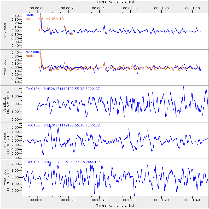
O18K Koktuh Hills, AK, USA - Earthquake Result Viewer
*The percent match for this event was below the threshold and hence no stack was calculated.
| Earthquake location: |
Loyalty Islands |
| Earthquake latitude/longitude: |
-21.3/168.5 |
| Earthquake time(UTC): |
2017/11/19 (323) 22:43:29 GMT |
| Earthquake Depth: |
25 km |
| Earthquake Magnitude: |
7.3 Mi |
| Earthquake Catalog/Contributor: |
NEIC PDE/at |
|
| Network: |
TA USArray Transportable Network (new EarthScope stations) |
| Station: |
O18K Koktuh Hills, AK, USA |
| Lat/Lon: |
59.85 N/155.21 W |
| Elevation: |
544 m |
|
| Distance: |
86.1 deg |
| Az: |
17.424 deg |
| Baz: |
213.588 deg |
| Ray Param: |
$rayparam |
*The percent match for this event was below the threshold and hence was not used in the summary stack. |
|
| Radial Match: |
82.17067 % |
| Radial Bump: |
400 |
| Transverse Match: |
66.178276 % |
| Transverse Bump: |
400 |
| SOD ConfigId: |
13570011 |
| Insert Time: |
2019-04-29 07:10:40.464 +0000 |
| GWidth: |
2.5 |
| Max Bumps: |
400 |
| Tol: |
0.001 |
|
Signal To Noise
| Channel | StoN | STA | LTA |
| TA:O18K: :BHZ:20171119T22:55:38.700012Z | 7.8724504 | 2.6184393E-6 | 3.3260793E-7 |
| TA:O18K: :BHN:20171119T22:55:38.700012Z | 1.8743172 | 8.2449657E-7 | 4.3989166E-7 |
| TA:O18K: :BHE:20171119T22:55:38.700012Z | 1.7650238 | 7.588653E-7 | 4.2994623E-7 |
| Arrivals |
| Ps | |
| PpPs | |
| PsPs/PpSs | |


