You are here: Home > Network List > TA - USArray Transportable Network (new EarthScope stations) Stations List
> Station V35K Ketchikan, AK, USA > Earthquake Result Viewer
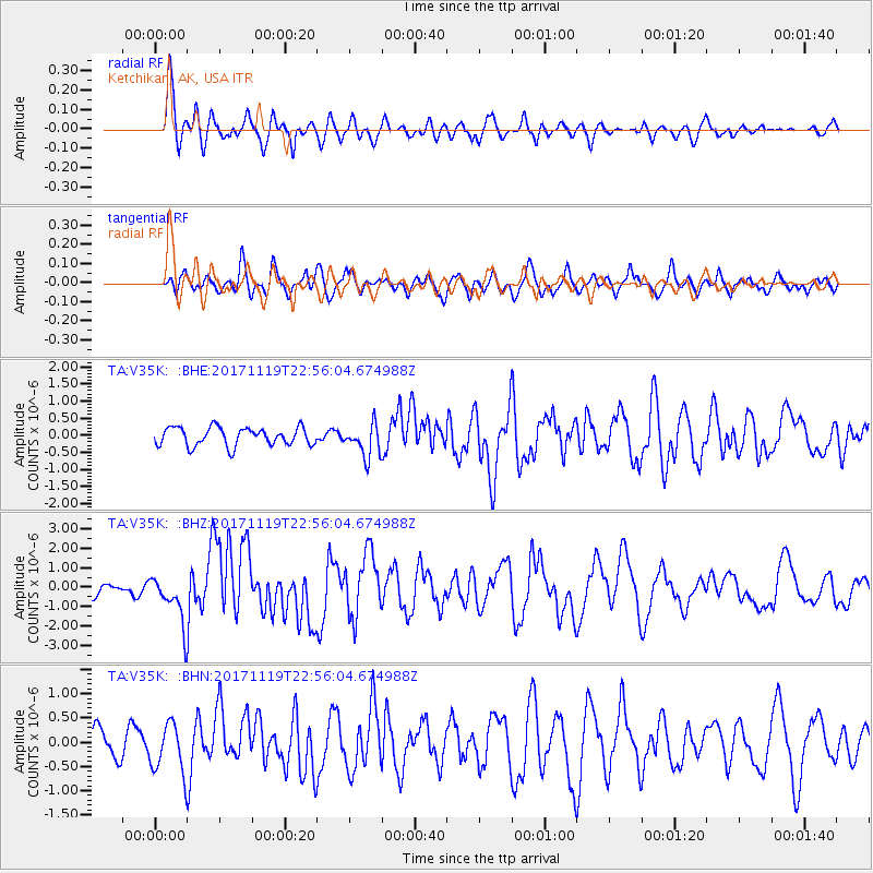
V35K Ketchikan, AK, USA - Earthquake Result Viewer
*The percent match for this event was below the threshold and hence no stack was calculated.
| Earthquake location: |
Loyalty Islands |
| Earthquake latitude/longitude: |
-21.3/168.5 |
| Earthquake time(UTC): |
2017/11/19 (323) 22:43:29 GMT |
| Earthquake Depth: |
25 km |
| Earthquake Magnitude: |
7.3 Mi |
| Earthquake Catalog/Contributor: |
NEIC PDE/at |
|
| Network: |
TA USArray Transportable Network (new EarthScope stations) |
| Station: |
V35K Ketchikan, AK, USA |
| Lat/Lon: |
55.33 N/131.62 W |
| Elevation: |
64 m |
|
| Distance: |
91.7 deg |
| Az: |
29.639 deg |
| Baz: |
233.802 deg |
| Ray Param: |
$rayparam |
*The percent match for this event was below the threshold and hence was not used in the summary stack. |
|
| Radial Match: |
76.582855 % |
| Radial Bump: |
400 |
| Transverse Match: |
63.760395 % |
| Transverse Bump: |
400 |
| SOD ConfigId: |
13570011 |
| Insert Time: |
2019-04-29 07:11:06.257 +0000 |
| GWidth: |
2.5 |
| Max Bumps: |
400 |
| Tol: |
0.001 |
|
Signal To Noise
| Channel | StoN | STA | LTA |
| TA:V35K: :BHZ:20171119T22:56:04.674988Z | 4.3568826 | 1.2701836E-6 | 2.9153495E-7 |
| TA:V35K: :BHN:20171119T22:56:04.674988Z | 1.9253762 | 5.274807E-7 | 2.7396243E-7 |
| TA:V35K: :BHE:20171119T22:56:04.674988Z | 1.2196612 | 3.2597453E-7 | 2.6726644E-7 |
| Arrivals |
| Ps | |
| PpPs | |
| PsPs/PpSs | |


