You are here: Home > Network List > TA - USArray Transportable Network (new EarthScope stations) Stations List
> Station A12A Yaak River Ranch, Troy, MT, USA > Earthquake Result Viewer
A12A Yaak River Ranch, Troy, MT, USA - Earthquake Result Viewer
| Earthquake location: |
Central Mid-Atlantic Ridge |
| Earthquake latitude/longitude: |
0.7/-30.3 |
| Earthquake time(UTC): |
2007/07/03 (184) 08:26:00 GMT |
| Earthquake Depth: |
10 km |
| Earthquake Magnitude: |
5.8 MB, 5.9 MS, 6.3 MW, 6.1 MW |
| Earthquake Catalog/Contributor: |
WHDF/NEIC |
|
| Network: |
TA USArray Transportable Network (new EarthScope stations) |
| Station: |
A12A Yaak River Ranch, Troy, MT, USA |
| Lat/Lon: |
48.93 N/115.65 W |
| Elevation: |
928 m |
|
| Distance: |
86.4 deg |
| Az: |
318.809 deg |
| Baz: |
93.008 deg |
| Ray Param: |
0.044064015 |
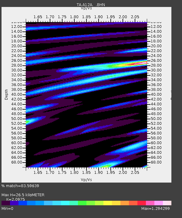
| Estimated Moho Depth: |
26.5 km |
| Estimated Crust Vp/Vs: |
2.10 |
| Assumed Crust Vp: |
6.622 km/s |
| Estimated Crust Vs: |
3.157 km/s |
| Estimated Crust Poisson's Ratio: |
0.35 |
|
| Radial Match: |
83.59639 % |
| Radial Bump: |
400 |
| Transverse Match: |
73.697334 % |
| Transverse Bump: |
400 |
| SOD ConfigId: |
2564 |
| Insert Time: |
2010-03-06 06:54:56.071 +0000 |
| GWidth: |
2.5 |
| Max Bumps: |
400 |
| Tol: |
0.001 |
|

Signal To Noise
| Channel | StoN | STA | LTA |
| TA:A12A: :BHN:20070703T08:38:11.849001Z | 1.0180736 | 4.623837E-8 | 4.5417515E-8 |
| TA:A12A: :BHE:20070703T08:38:11.849001Z | 1.2881739 | 7.488217E-8 | 5.813048E-8 |
| TA:A12A: :BHZ:20070703T08:38:11.849001Z | 2.919251 | 1.6731684E-7 | 5.731499E-8 |
| Arrivals |
| Ps | 4.5 SECOND |
| PpPs | 12 SECOND |
| PsPs/PpSs | 17 SECOND |


