You are here: Home > Network List > UW - Pacific Northwest Regional Seismic Network Stations List
> Station FISH Seaside, OR, USA > Earthquake Result Viewer
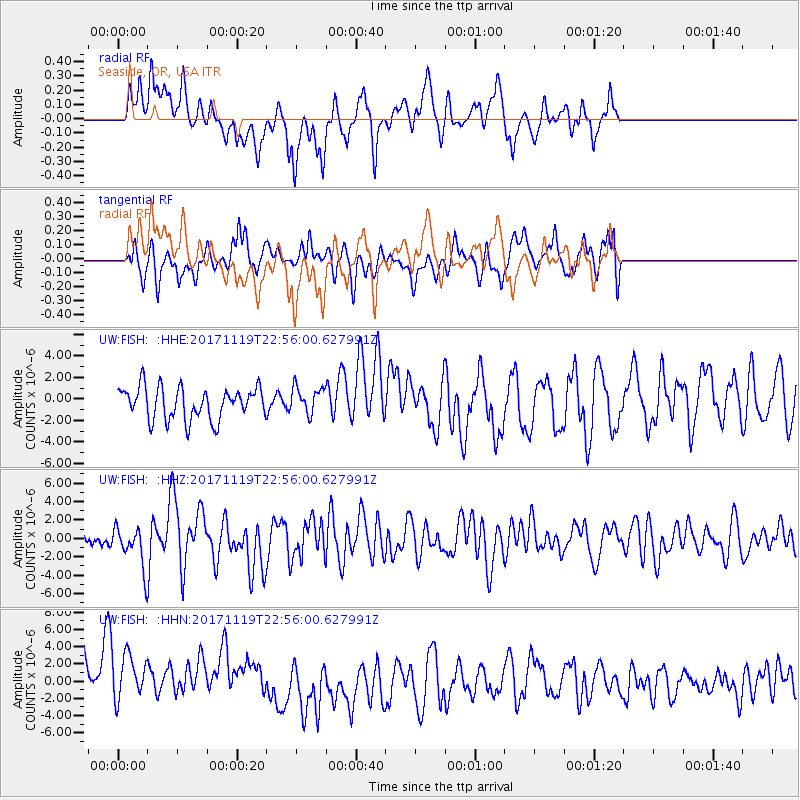
FISH Seaside, OR, USA - Earthquake Result Viewer
*The percent match for this event was below the threshold and hence no stack was calculated.
| Earthquake location: |
Loyalty Islands |
| Earthquake latitude/longitude: |
-21.3/168.5 |
| Earthquake time(UTC): |
2017/11/19 (323) 22:43:29 GMT |
| Earthquake Depth: |
25 km |
| Earthquake Magnitude: |
7.3 Mi |
| Earthquake Catalog/Contributor: |
NEIC PDE/at |
|
| Network: |
UW Pacific Northwest Regional Seismic Network |
| Station: |
FISH Seaside, OR, USA |
| Lat/Lon: |
45.93 N/123.56 W |
| Elevation: |
325 m |
|
| Distance: |
90.8 deg |
| Az: |
40.309 deg |
| Baz: |
239.807 deg |
| Ray Param: |
$rayparam |
*The percent match for this event was below the threshold and hence was not used in the summary stack. |
|
| Radial Match: |
53.94239 % |
| Radial Bump: |
400 |
| Transverse Match: |
44.578995 % |
| Transverse Bump: |
400 |
| SOD ConfigId: |
13570011 |
| Insert Time: |
2019-04-29 07:11:49.218 +0000 |
| GWidth: |
2.5 |
| Max Bumps: |
400 |
| Tol: |
0.001 |
|
Signal To Noise
| Channel | StoN | STA | LTA |
| UW:FISH: :HHZ:20171119T22:56:00.627991Z | 2.0981393 | 2.1141002E-6 | 1.007607E-6 |
| UW:FISH: :HHN:20171119T22:56:00.627991Z | 1.1286895 | 3.4134475E-6 | 3.0242575E-6 |
| UW:FISH: :HHE:20171119T22:56:00.627991Z | 0.7870467 | 1.1629766E-6 | 1.4776464E-6 |
| Arrivals |
| Ps | |
| PpPs | |
| PsPs/PpSs | |


