You are here: Home > Network List > TA - USArray Transportable Network (new EarthScope stations) Stations List
> Station A12A Yaak River Ranch, Troy, MT, USA > Earthquake Result Viewer
A12A Yaak River Ranch, Troy, MT, USA - Earthquake Result Viewer
| Earthquake location: |
Fiji Islands Region |
| Earthquake latitude/longitude: |
-17.3/-177.3 |
| Earthquake time(UTC): |
2008/07/19 (201) 22:39:52 GMT |
| Earthquake Depth: |
391 km |
| Earthquake Magnitude: |
5.9 MB, 6.4 MW, 6.4 MW |
| Earthquake Catalog/Contributor: |
WHDF/NEIC |
|
| Network: |
TA USArray Transportable Network (new EarthScope stations) |
| Station: |
A12A Yaak River Ranch, Troy, MT, USA |
| Lat/Lon: |
48.93 N/115.65 W |
| Elevation: |
928 m |
|
| Distance: |
85.6 deg |
| Az: |
35.598 deg |
| Baz: |
237.47 deg |
| Ray Param: |
0.043610904 |
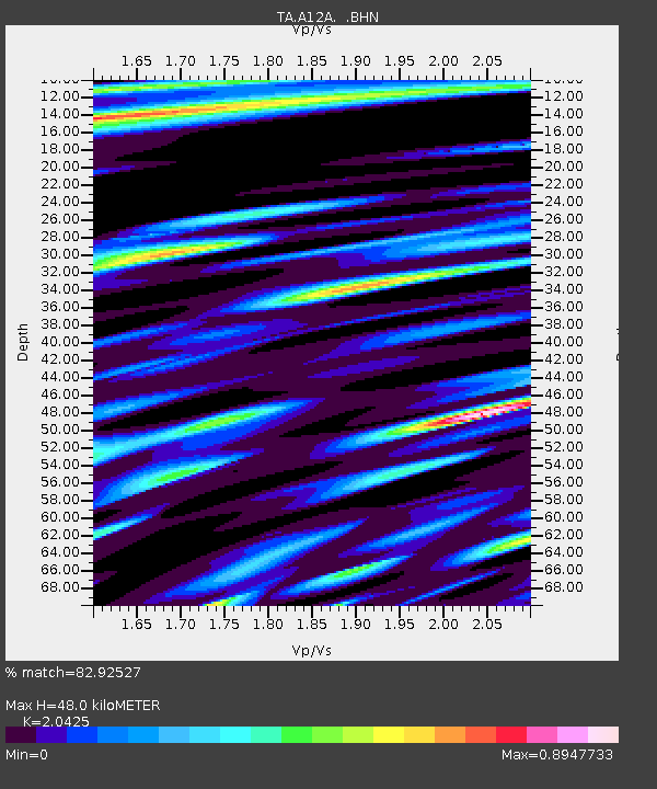
| Estimated Moho Depth: |
48.0 km |
| Estimated Crust Vp/Vs: |
2.04 |
| Assumed Crust Vp: |
6.622 km/s |
| Estimated Crust Vs: |
3.242 km/s |
| Estimated Crust Poisson's Ratio: |
0.34 |
|
| Radial Match: |
82.92527 % |
| Radial Bump: |
400 |
| Transverse Match: |
74.39647 % |
| Transverse Bump: |
400 |
| SOD ConfigId: |
2504 |
| Insert Time: |
2010-03-06 06:55:47.699 +0000 |
| GWidth: |
2.5 |
| Max Bumps: |
400 |
| Tol: |
0.001 |
|
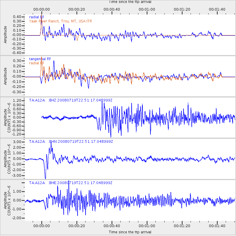
Signal To Noise
| Channel | StoN | STA | LTA |
| TA:A12A: :BHN:20080719T22:51:17.048999Z | 20.328522 | 1.4083134E-6 | 6.927771E-8 |
| TA:A12A: :BHE:20080719T22:51:17.048999Z | 5.4110994 | 4.244384E-7 | 7.843848E-8 |
| TA:A12A: :BHZ:20080719T22:51:17.048999Z | 8.067172 | 4.7529116E-7 | 5.89167E-8 |
| Arrivals |
| Ps | 7.7 SECOND |
| PpPs | 22 SECOND |
| PsPs/PpSs | 29 SECOND |


