You are here: Home > Network List > TA - USArray Transportable Network (new EarthScope stations) Stations List
> Station R17K Ugashik Creek, AK, USA > Earthquake Result Viewer
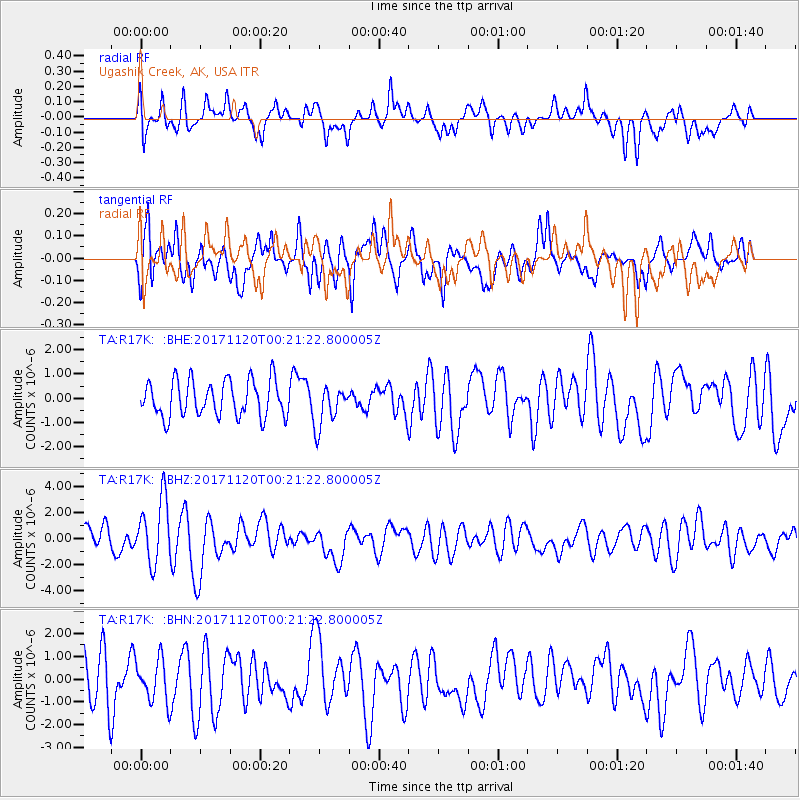
R17K Ugashik Creek, AK, USA - Earthquake Result Viewer
*The percent match for this event was below the threshold and hence no stack was calculated.
| Earthquake location: |
Loyalty Islands |
| Earthquake latitude/longitude: |
-21.5/168.8 |
| Earthquake time(UTC): |
2017/11/20 (324) 00:09:23 GMT |
| Earthquake Depth: |
10 km |
| Earthquake Magnitude: |
6.0 Mww |
| Earthquake Catalog/Contributor: |
NEIC PDE/us |
|
| Network: |
TA USArray Transportable Network (new EarthScope stations) |
| Station: |
R17K Ugashik Creek, AK, USA |
| Lat/Lon: |
57.64 N/156.39 W |
| Elevation: |
273 m |
|
| Distance: |
84.0 deg |
| Az: |
17.97 deg |
| Baz: |
212.289 deg |
| Ray Param: |
$rayparam |
*The percent match for this event was below the threshold and hence was not used in the summary stack. |
|
| Radial Match: |
57.85436 % |
| Radial Bump: |
400 |
| Transverse Match: |
61.537453 % |
| Transverse Bump: |
400 |
| SOD ConfigId: |
13570011 |
| Insert Time: |
2019-04-29 07:17:01.664 +0000 |
| GWidth: |
2.5 |
| Max Bumps: |
400 |
| Tol: |
0.001 |
|
Signal To Noise
| Channel | StoN | STA | LTA |
| TA:R17K: :BHZ:20171120T00:21:22.800005Z | 2.6691964 | 2.439567E-6 | 9.1397067E-7 |
| TA:R17K: :BHN:20171120T00:21:22.800005Z | 0.94504654 | 9.201216E-7 | 9.736257E-7 |
| TA:R17K: :BHE:20171120T00:21:22.800005Z | 1.1491754 | 8.529457E-7 | 7.4222413E-7 |
| Arrivals |
| Ps | |
| PpPs | |
| PsPs/PpSs | |


