You are here: Home > Network List > TA - USArray Transportable Network (new EarthScope stations) Stations List
> Station A12A Yaak River Ranch, Troy, MT, USA > Earthquake Result Viewer
A12A Yaak River Ranch, Troy, MT, USA - Earthquake Result Viewer
| Earthquake location: |
Kuril Islands |
| Earthquake latitude/longitude: |
49.9/156.4 |
| Earthquake time(UTC): |
2008/08/04 (217) 04:42:14 GMT |
| Earthquake Depth: |
77 km |
| Earthquake Magnitude: |
5.6 MB, 5.8 MW, 5.7 MW |
| Earthquake Catalog/Contributor: |
WHDF/NEIC |
|
| Network: |
TA USArray Transportable Network (new EarthScope stations) |
| Station: |
A12A Yaak River Ranch, Troy, MT, USA |
| Lat/Lon: |
48.93 N/115.65 W |
| Elevation: |
928 m |
|
| Distance: |
54.0 deg |
| Az: |
54.575 deg |
| Baz: |
306.883 deg |
| Ray Param: |
0.06552593 |
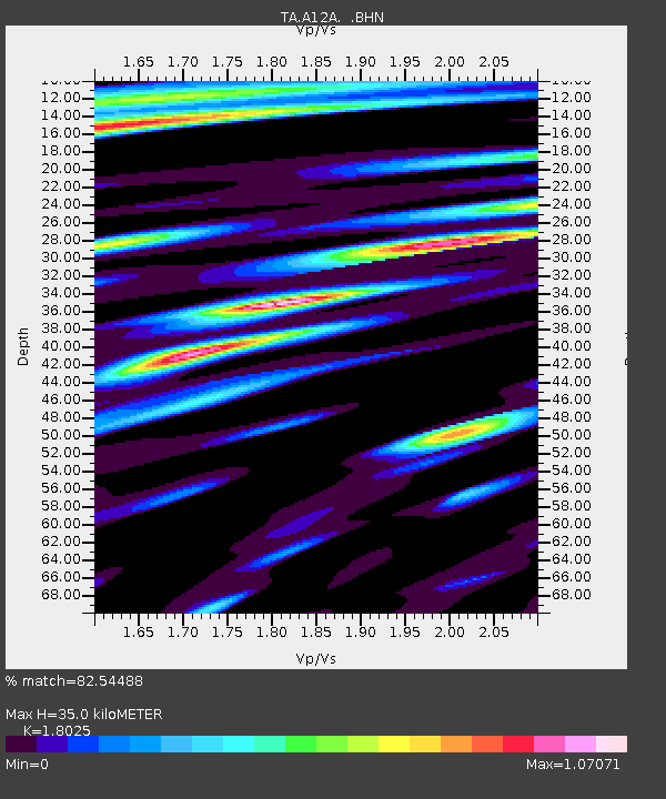
| Estimated Moho Depth: |
35.0 km |
| Estimated Crust Vp/Vs: |
1.80 |
| Assumed Crust Vp: |
6.622 km/s |
| Estimated Crust Vs: |
3.674 km/s |
| Estimated Crust Poisson's Ratio: |
0.28 |
|
| Radial Match: |
82.54488 % |
| Radial Bump: |
400 |
| Transverse Match: |
76.6058 % |
| Transverse Bump: |
400 |
| SOD ConfigId: |
2504 |
| Insert Time: |
2010-03-06 06:55:51.949 +0000 |
| GWidth: |
2.5 |
| Max Bumps: |
400 |
| Tol: |
0.001 |
|
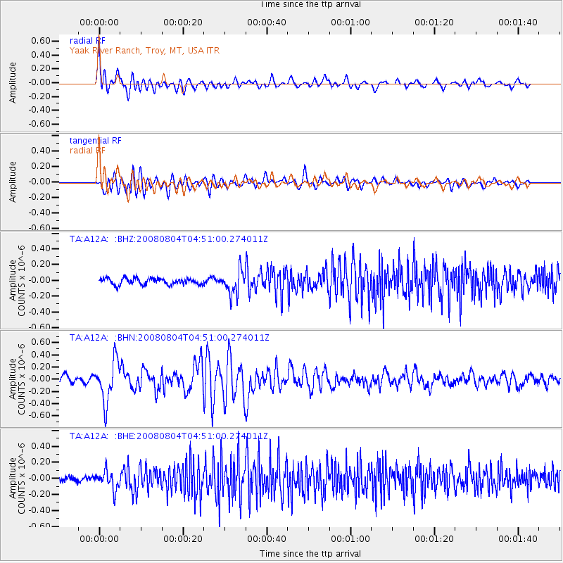
Signal To Noise
| Channel | StoN | STA | LTA |
| TA:A12A: :BHN:20080804T04:51:00.274011Z | 5.7892175 | 3.4626896E-7 | 5.981274E-8 |
| TA:A12A: :BHE:20080804T04:51:00.274011Z | 3.9630969 | 1.1839646E-7 | 2.987473E-8 |
| TA:A12A: :BHZ:20080804T04:51:00.274011Z | 3.8871305 | 1.5157389E-7 | 3.899377E-8 |
| Arrivals |
| Ps | 4.5 SECOND |
| PpPs | 14 SECOND |
| PsPs/PpSs | 18 SECOND |


