You are here: Home > Network List > UW - Pacific Northwest Regional Seismic Network Stations List
> Station UMAT Pilot Rock, OR, USA > Earthquake Result Viewer
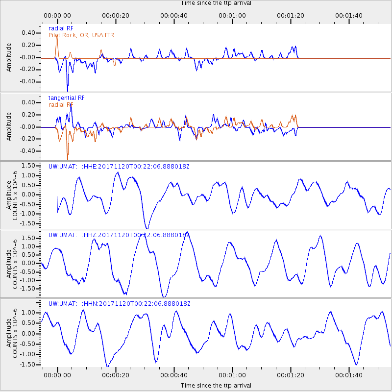
UMAT Pilot Rock, OR, USA - Earthquake Result Viewer
*The percent match for this event was below the threshold and hence no stack was calculated.
| Earthquake location: |
Loyalty Islands |
| Earthquake latitude/longitude: |
-21.5/168.8 |
| Earthquake time(UTC): |
2017/11/20 (324) 00:09:23 GMT |
| Earthquake Depth: |
10 km |
| Earthquake Magnitude: |
6.0 Mww |
| Earthquake Catalog/Contributor: |
NEIC PDE/us |
|
| Network: |
UW Pacific Northwest Regional Seismic Network |
| Station: |
UMAT Pilot Rock, OR, USA |
| Lat/Lon: |
45.29 N/118.96 W |
| Elevation: |
1318 m |
|
| Distance: |
93.3 deg |
| Az: |
42.321 deg |
| Baz: |
242.643 deg |
| Ray Param: |
$rayparam |
*The percent match for this event was below the threshold and hence was not used in the summary stack. |
|
| Radial Match: |
66.52318 % |
| Radial Bump: |
400 |
| Transverse Match: |
54.85787 % |
| Transverse Bump: |
397 |
| SOD ConfigId: |
13570011 |
| Insert Time: |
2019-04-29 07:17:47.166 +0000 |
| GWidth: |
2.5 |
| Max Bumps: |
400 |
| Tol: |
0.001 |
|
Signal To Noise
| Channel | StoN | STA | LTA |
| UW:UMAT: :HHZ:20171120T00:22:06.888018Z | 1.0129964 | 7.247177E-7 | 7.154198E-7 |
| UW:UMAT: :HHN:20171120T00:22:06.888018Z | 0.8598883 | 5.3821503E-7 | 6.259127E-7 |
| UW:UMAT: :HHE:20171120T00:22:06.888018Z | 1.8600754 | 1.1363034E-6 | 6.1089105E-7 |
| Arrivals |
| Ps | |
| PpPs | |
| PsPs/PpSs | |


