You are here: Home > Network List > TA - USArray Transportable Network (new EarthScope stations) Stations List
> Station 833A Chaparral WMA, Artesia Wells, TX, USA > Earthquake Result Viewer
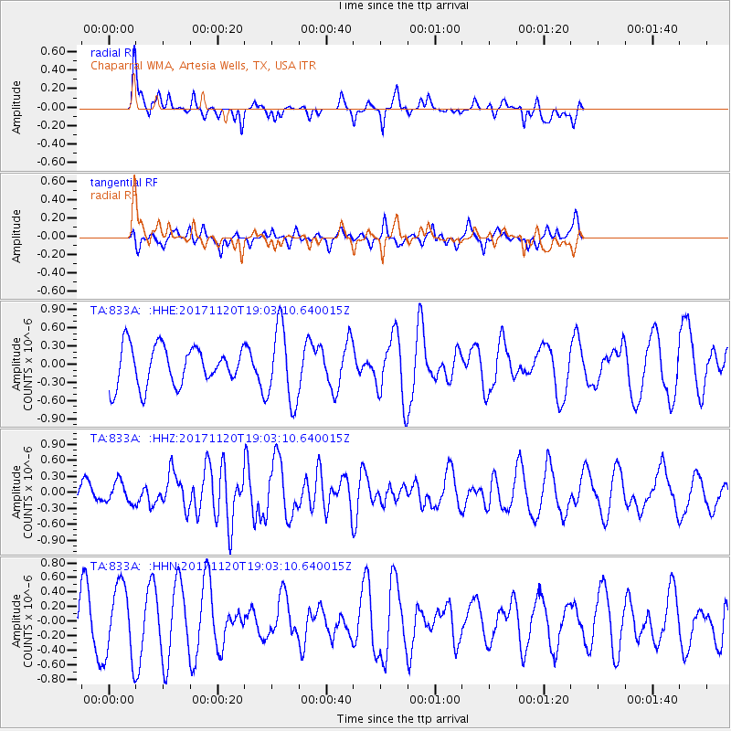
833A Chaparral WMA, Artesia Wells, TX, USA - Earthquake Result Viewer
*The percent match for this event was below the threshold and hence no stack was calculated.
| Earthquake location: |
Samoa Islands Region |
| Earthquake latitude/longitude: |
-14.4/-175.1 |
| Earthquake time(UTC): |
2017/11/20 (324) 18:51:04 GMT |
| Earthquake Depth: |
10 km |
| Earthquake Magnitude: |
6.2 Mi |
| Earthquake Catalog/Contributor: |
NEIC PDE/pt |
|
| Network: |
TA USArray Transportable Network (new EarthScope stations) |
| Station: |
833A Chaparral WMA, Artesia Wells, TX, USA |
| Lat/Lon: |
28.32 N/99.39 W |
| Elevation: |
171 m |
|
| Distance: |
84.6 deg |
| Az: |
59.122 deg |
| Baz: |
250.646 deg |
| Ray Param: |
$rayparam |
*The percent match for this event was below the threshold and hence was not used in the summary stack. |
|
| Radial Match: |
47.858906 % |
| Radial Bump: |
324 |
| Transverse Match: |
38.29465 % |
| Transverse Bump: |
268 |
| SOD ConfigId: |
13570011 |
| Insert Time: |
2019-04-29 07:23:18.917 +0000 |
| GWidth: |
2.5 |
| Max Bumps: |
400 |
| Tol: |
0.001 |
|
Signal To Noise
| Channel | StoN | STA | LTA |
| TA:833A: :HHZ:20171120T19:03:10.640015Z | 0.77182025 | 1.983201E-7 | 2.5695115E-7 |
| TA:833A: :HHN:20171120T19:03:10.640015Z | 1.6792343 | 5.052255E-7 | 3.008666E-7 |
| TA:833A: :HHE:20171120T19:03:10.640015Z | 1.0092561 | 3.4703922E-7 | 3.438564E-7 |
| Arrivals |
| Ps | |
| PpPs | |
| PsPs/PpSs | |


