You are here: Home > Network List > TA - USArray Transportable Network (new EarthScope stations) Stations List
> Station G23K Bananza Creek, AK, USA > Earthquake Result Viewer
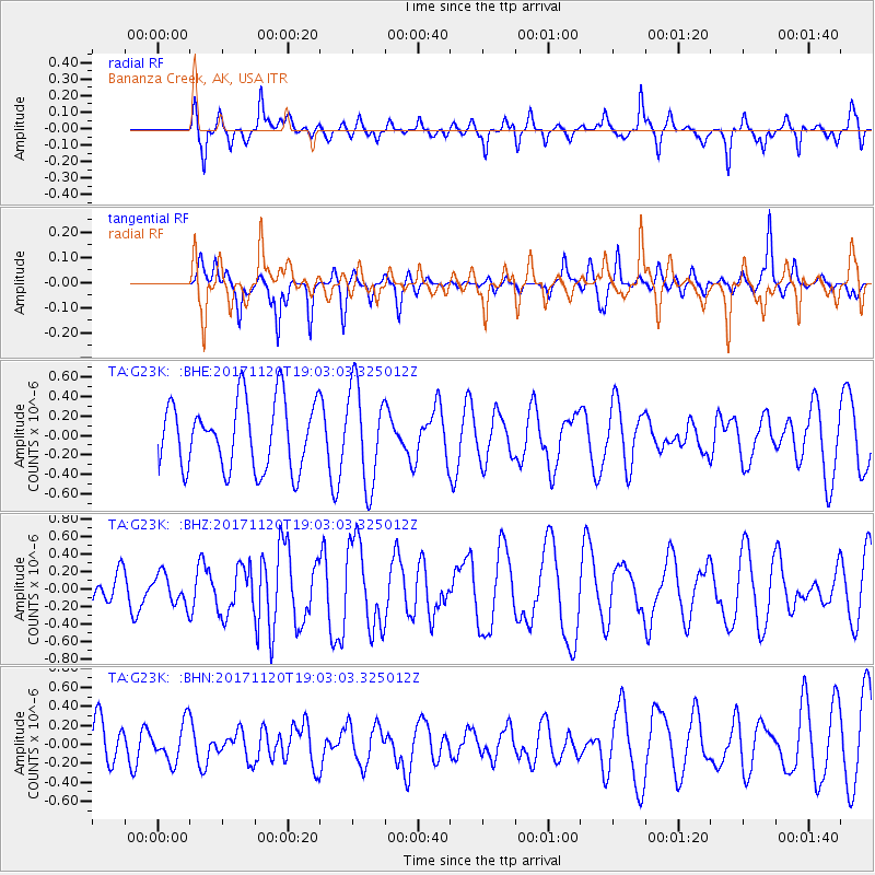
G23K Bananza Creek, AK, USA - Earthquake Result Viewer
*The percent match for this event was below the threshold and hence no stack was calculated.
| Earthquake location: |
Samoa Islands Region |
| Earthquake latitude/longitude: |
-14.4/-175.1 |
| Earthquake time(UTC): |
2017/11/20 (324) 18:51:04 GMT |
| Earthquake Depth: |
10 km |
| Earthquake Magnitude: |
6.2 Mi |
| Earthquake Catalog/Contributor: |
NEIC PDE/pt |
|
| Network: |
TA USArray Transportable Network (new EarthScope stations) |
| Station: |
G23K Bananza Creek, AK, USA |
| Lat/Lon: |
66.71 N/150.02 W |
| Elevation: |
746 m |
|
| Distance: |
82.9 deg |
| Az: |
9.79 deg |
| Baz: |
204.484 deg |
| Ray Param: |
$rayparam |
*The percent match for this event was below the threshold and hence was not used in the summary stack. |
|
| Radial Match: |
66.77927 % |
| Radial Bump: |
382 |
| Transverse Match: |
36.94889 % |
| Transverse Bump: |
236 |
| SOD ConfigId: |
13570011 |
| Insert Time: |
2019-04-29 07:23:30.103 +0000 |
| GWidth: |
2.5 |
| Max Bumps: |
400 |
| Tol: |
0.001 |
|
Signal To Noise
| Channel | StoN | STA | LTA |
| TA:G23K: :BHZ:20171120T19:03:03.325012Z | 1.0549107 | 1.7645255E-7 | 1.6726776E-7 |
| TA:G23K: :BHN:20171120T19:03:03.325012Z | 1.1044469 | 2.053071E-7 | 1.8589132E-7 |
| TA:G23K: :BHE:20171120T19:03:03.325012Z | 1.1451055 | 3.9562988E-7 | 3.4549643E-7 |
| Arrivals |
| Ps | |
| PpPs | |
| PsPs/PpSs | |


