You are here: Home > Network List > TA - USArray Transportable Network (new EarthScope stations) Stations List
> Station A12A Yaak River Ranch, Troy, MT, USA > Earthquake Result Viewer
A12A Yaak River Ranch, Troy, MT, USA - Earthquake Result Viewer
| Earthquake location: |
South Of Panama |
| Earthquake latitude/longitude: |
5.7/-82.8 |
| Earthquake time(UTC): |
2009/03/12 (071) 23:23:34 GMT |
| Earthquake Depth: |
9.0 km |
| Earthquake Magnitude: |
6.1 MB, 5.9 MS, 6.3 MW, 6.2 MW |
| Earthquake Catalog/Contributor: |
WHDF/NEIC |
|
| Network: |
TA USArray Transportable Network (new EarthScope stations) |
| Station: |
A12A Yaak River Ranch, Troy, MT, USA |
| Lat/Lon: |
48.93 N/115.65 W |
| Elevation: |
928 m |
|
| Distance: |
51.3 deg |
| Az: |
332.697 deg |
| Baz: |
136.194 deg |
| Ray Param: |
0.06749495 |
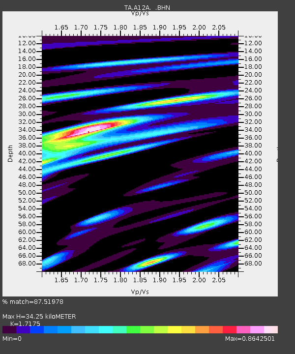
| Estimated Moho Depth: |
34.25 km |
| Estimated Crust Vp/Vs: |
1.72 |
| Assumed Crust Vp: |
6.622 km/s |
| Estimated Crust Vs: |
3.856 km/s |
| Estimated Crust Poisson's Ratio: |
0.24 |
|
| Radial Match: |
87.51978 % |
| Radial Bump: |
400 |
| Transverse Match: |
72.26756 % |
| Transverse Bump: |
400 |
| SOD ConfigId: |
2658 |
| Insert Time: |
2010-03-06 06:56:42.656 +0000 |
| GWidth: |
2.5 |
| Max Bumps: |
400 |
| Tol: |
0.001 |
|

Signal To Noise
| Channel | StoN | STA | LTA |
| TA:A12A: :BHN:20090312T23:32:08.249016Z | 5.7399507 | 1.1845561E-6 | 2.0637044E-7 |
| TA:A12A: :BHE:20090312T23:32:08.249016Z | 4.8029385 | 4.843748E-7 | 1.00849675E-7 |
| TA:A12A: :BHZ:20090312T23:32:08.249016Z | 4.947973 | 5.6842777E-7 | 1.1488093E-7 |
| Arrivals |
| Ps | 4.0 SECOND |
| PpPs | 13 SECOND |
| PsPs/PpSs | 17 SECOND |


