You are here: Home > Network List > TA - USArray Transportable Network (new EarthScope stations) Stations List
> Station A12A Yaak River Ranch, Troy, MT, USA > Earthquake Result Viewer
A12A Yaak River Ranch, Troy, MT, USA - Earthquake Result Viewer
| Earthquake location: |
Southern Peru |
| Earthquake latitude/longitude: |
-15.0/-70.4 |
| Earthquake time(UTC): |
2009/07/12 (193) 06:12:47 GMT |
| Earthquake Depth: |
199 km |
| Earthquake Magnitude: |
5.7 MB, 6.1 MW, 6.1 MW |
| Earthquake Catalog/Contributor: |
WHDF/NEIC |
|
| Network: |
TA USArray Transportable Network (new EarthScope stations) |
| Station: |
A12A Yaak River Ranch, Troy, MT, USA |
| Lat/Lon: |
48.93 N/115.65 W |
| Elevation: |
928 m |
|
| Distance: |
75.2 deg |
| Az: |
331.054 deg |
| Baz: |
134.838 deg |
| Ray Param: |
0.051286805 |
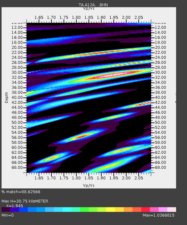
| Estimated Moho Depth: |
30.75 km |
| Estimated Crust Vp/Vs: |
1.95 |
| Assumed Crust Vp: |
6.622 km/s |
| Estimated Crust Vs: |
3.405 km/s |
| Estimated Crust Poisson's Ratio: |
0.32 |
|
| Radial Match: |
88.62566 % |
| Radial Bump: |
400 |
| Transverse Match: |
83.89532 % |
| Transverse Bump: |
400 |
| SOD ConfigId: |
2648 |
| Insert Time: |
2010-03-06 06:57:01.896 +0000 |
| GWidth: |
2.5 |
| Max Bumps: |
400 |
| Tol: |
0.001 |
|
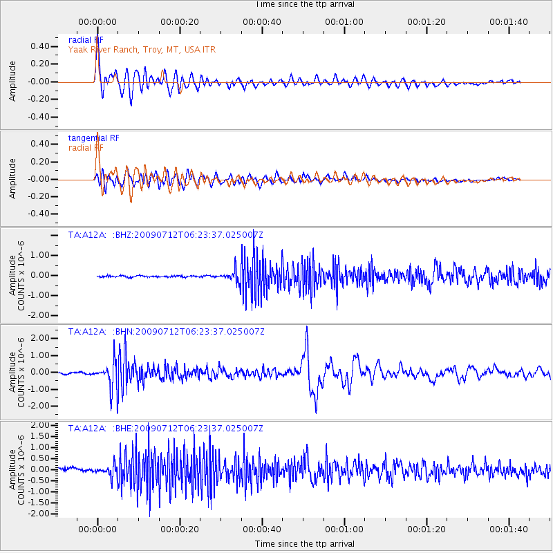
Signal To Noise
| Channel | StoN | STA | LTA |
| TA:A12A: :BHN:20090712T06:23:37.025007Z | 20.811153 | 7.9949126E-7 | 3.841648E-8 |
| TA:A12A: :BHE:20090712T06:23:37.025007Z | 2.9288514 | 2.4405773E-7 | 8.332882E-8 |
| TA:A12A: :BHZ:20090712T06:23:37.025007Z | 9.378837 | 2.8860637E-7 | 3.077209E-8 |
| Arrivals |
| Ps | 4.5 SECOND |
| PpPs | 13 SECOND |
| PsPs/PpSs | 18 SECOND |


