You are here: Home > Network List > TA - USArray Transportable Network (new EarthScope stations) Stations List
> Station A12A Yaak River Ranch, Troy, MT, USA > Earthquake Result Viewer
A12A Yaak River Ranch, Troy, MT, USA - Earthquake Result Viewer

| Earthquake location: |
Kuril Islands |
| Earthquake latitude/longitude: |
46.9/153.7 |
| Earthquake time(UTC): |
2006/11/15 (319) 11:33:23 GMT |
| Earthquake Depth: |
10 km |
| Earthquake Magnitude: |
5.5 MB |
| Earthquake Catalog/Contributor: |
WHDF/NEIC |
|
| Network: |
TA USArray Transportable Network (new EarthScope stations) |
| Station: |
A12A Yaak River Ranch, Troy, MT, USA |
| Lat/Lon: |
48.93 N/115.65 W |
| Elevation: |
928 m |
|
| Distance: |
57.2 deg |
| Az: |
51.686 deg |
| Baz: |
305.267 deg |
| Ray Param: |
0.06365381 |
| Estimated Moho Depth: |
14.5 km |
| Estimated Crust Vp/Vs: |
1.60 |
| Assumed Crust Vp: |
6.622 km/s |
| Estimated Crust Vs: |
4.139 km/s |
| Estimated Crust Poisson's Ratio: |
0.18 |
|
| Radial Match: |
92.74138 % |
| Radial Bump: |
366 |
| Transverse Match: |
85.502846 % |
| Transverse Bump: |
312 |
| SOD ConfigId: |
2564 |
| Insert Time: |
2010-03-06 06:57:05.018 +0000 |
| GWidth: |
2.5 |
| Max Bumps: |
400 |
| Tol: |
0.001 |
|
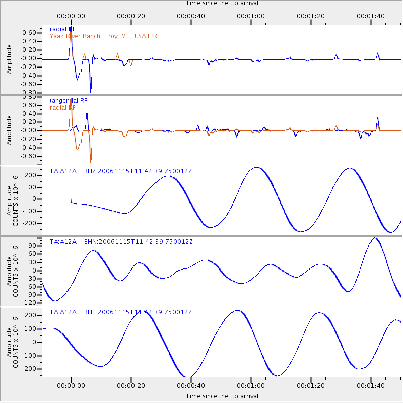
Signal To Noise
| Channel | StoN | STA | LTA |
| TA:A12A: :BHN:20061115T11:42:39.750012Z | 0.7845939 | 4.051999E-5 | 5.164454E-5 |
| TA:A12A: :BHE:20061115T11:42:39.750012Z | 0.894226 | 7.937308E-5 | 8.8761764E-5 |
| TA:A12A: :BHZ:20061115T11:42:39.750012Z | 6.4205422 | 2.4656107E-4 | 3.840191E-5 |
| Arrivals |
| Ps | 1.4 SECOND |
| PpPs | 5.4 SECOND |
| PsPs/PpSs | 6.8 SECOND |


