You are here: Home > Network List > TA - USArray Transportable Network (new EarthScope stations) Stations List
> Station A12A Yaak River Ranch, Troy, MT, USA > Earthquake Result Viewer
A12A Yaak River Ranch, Troy, MT, USA - Earthquake Result Viewer
| Earthquake location: |
New Britain Region, P.N.G. |
| Earthquake latitude/longitude: |
-5.9/151.0 |
| Earthquake time(UTC): |
2006/10/17 (290) 01:25:12 GMT |
| Earthquake Depth: |
32 km |
| Earthquake Magnitude: |
6.4 MB, 6.9 MS, 6.7 MW, 6.6 MW |
| Earthquake Catalog/Contributor: |
WHDF/NEIC |
|
| Network: |
TA USArray Transportable Network (new EarthScope stations) |
| Station: |
A12A Yaak River Ranch, Troy, MT, USA |
| Lat/Lon: |
48.93 N/115.65 W |
| Elevation: |
928 m |
|
| Distance: |
96.6 deg |
| Az: |
41.506 deg |
| Baz: |
268.661 deg |
| Ray Param: |
0.040449888 |
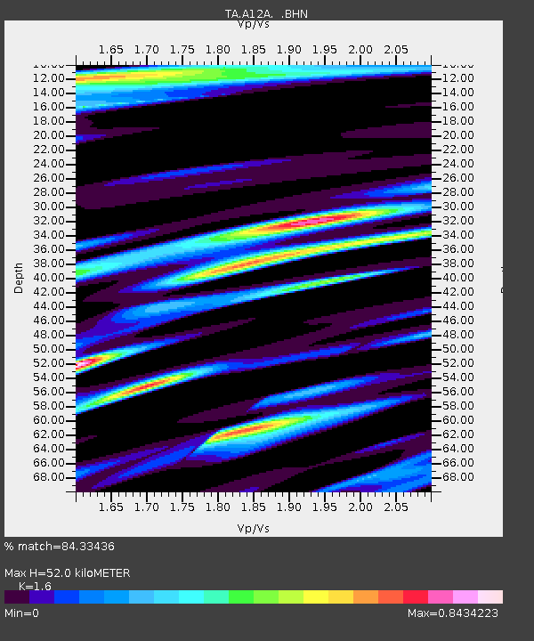
| Estimated Moho Depth: |
52.0 km |
| Estimated Crust Vp/Vs: |
1.60 |
| Assumed Crust Vp: |
6.622 km/s |
| Estimated Crust Vs: |
4.139 km/s |
| Estimated Crust Poisson's Ratio: |
0.18 |
|
| Radial Match: |
84.33436 % |
| Radial Bump: |
400 |
| Transverse Match: |
64.36542 % |
| Transverse Bump: |
400 |
| SOD ConfigId: |
2665 |
| Insert Time: |
2010-03-06 06:57:15.073 +0000 |
| GWidth: |
2.5 |
| Max Bumps: |
400 |
| Tol: |
0.001 |
|
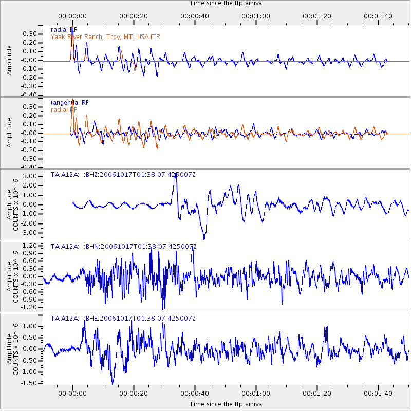
Signal To Noise
| Channel | StoN | STA | LTA |
| TA:A12A: :BHN:20061017T01:38:07.425007Z | 0.825858 | 1.7871758E-7 | 2.1640231E-7 |
| TA:A12A: :BHE:20061017T01:38:07.425007Z | 1.5791683 | 4.1407768E-7 | 2.622125E-7 |
| TA:A12A: :BHZ:20061017T01:38:07.425007Z | 6.7114463 | 1.4223654E-6 | 2.1193127E-7 |
| Arrivals |
| Ps | 4.8 SECOND |
| PpPs | 20 SECOND |
| PsPs/PpSs | 25 SECOND |


