You are here: Home > Network List > TA - USArray Transportable Network (new EarthScope stations) Stations List
> Station J20K Nowitna River, AK, USA > Earthquake Result Viewer
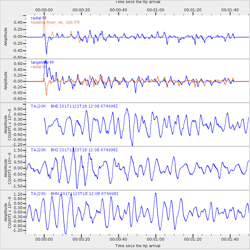
J20K Nowitna River, AK, USA - Earthquake Result Viewer
*The percent match for this event was below the threshold and hence no stack was calculated.
| Earthquake location: |
Ryukyu Islands, Japan |
| Earthquake latitude/longitude: |
27.1/130.4 |
| Earthquake time(UTC): |
2017/11/23 (327) 18:02:35 GMT |
| Earthquake Depth: |
10 km |
| Earthquake Magnitude: |
5.5 Mww |
| Earthquake Catalog/Contributor: |
NEIC PDE/us |
|
| Network: |
TA USArray Transportable Network (new EarthScope stations) |
| Station: |
J20K Nowitna River, AK, USA |
| Lat/Lon: |
64.18 N/154.15 W |
| Elevation: |
314 m |
|
| Distance: |
59.6 deg |
| Az: |
29.439 deg |
| Baz: |
269.86 deg |
| Ray Param: |
$rayparam |
*The percent match for this event was below the threshold and hence was not used in the summary stack. |
|
| Radial Match: |
60.54872 % |
| Radial Bump: |
340 |
| Transverse Match: |
69.00957 % |
| Transverse Bump: |
400 |
| SOD ConfigId: |
13570011 |
| Insert Time: |
2019-04-29 07:30:59.731 +0000 |
| GWidth: |
2.5 |
| Max Bumps: |
400 |
| Tol: |
0.001 |
|
Signal To Noise
| Channel | StoN | STA | LTA |
| TA:J20K: :BHZ:20171123T18:12:08.674998Z | 1.361468 | 4.4911616E-7 | 3.298764E-7 |
| TA:J20K: :BHN:20171123T18:12:08.674998Z | 2.9961073 | 8.057249E-7 | 2.689239E-7 |
| TA:J20K: :BHE:20171123T18:12:08.674998Z | 0.93372613 | 3.3853536E-7 | 3.625639E-7 |
| Arrivals |
| Ps | |
| PpPs | |
| PsPs/PpSs | |


