You are here: Home > Network List > AT - Alaska Tsunami Warning Seismic System Stations List
> Station OHAK Old Harbor, Alaska > Earthquake Result Viewer
OHAK Old Harbor, Alaska - Earthquake Result Viewer
| Earthquake location: |
Vanuatu Islands Region |
| Earthquake latitude/longitude: |
-20.6/172.6 |
| Earthquake time(UTC): |
2017/11/25 (329) 17:30:01 GMT |
| Earthquake Depth: |
10 km |
| Earthquake Magnitude: |
5.8 Mww |
| Earthquake Catalog/Contributor: |
NEIC PDE/us |
|
| Network: |
AT Alaska Tsunami Warning Seismic System |
| Station: |
OHAK Old Harbor, Alaska |
| Lat/Lon: |
57.22 N/153.29 W |
| Elevation: |
78 m |
|
| Distance: |
82.7 deg |
| Az: |
17.93 deg |
| Baz: |
212.016 deg |
| Ray Param: |
0.04673898 |
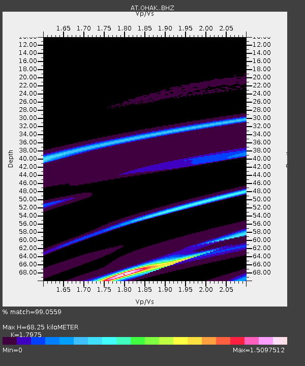
| Estimated Moho Depth: |
68.25 km |
| Estimated Crust Vp/Vs: |
1.80 |
| Assumed Crust Vp: |
6.134 km/s |
| Estimated Crust Vs: |
3.412 km/s |
| Estimated Crust Poisson's Ratio: |
0.28 |
|
| Radial Match: |
99.0559 % |
| Radial Bump: |
99 |
| Transverse Match: |
99.16539 % |
| Transverse Bump: |
115 |
| SOD ConfigId: |
13570011 |
| Insert Time: |
2019-04-29 07:32:59.004 +0000 |
| GWidth: |
2.5 |
| Max Bumps: |
400 |
| Tol: |
0.001 |
|

Signal To Noise
| Channel | StoN | STA | LTA |
| AT:OHAK: :BHZ:20171125T17:41:53.779983Z | 0.97764945 | 7.03891E-8 | 7.19983E-8 |
| AT:OHAK: :BHN:20171125T17:41:53.779983Z | 0.95687526 | 7.835447E-7 | 8.188577E-7 |
| AT:OHAK: :BHE:20171125T17:41:53.779983Z | 1.1631052 | 2.2618616E-8 | 1.9446748E-8 |
| Arrivals |
| Ps | 9.1 SECOND |
| PpPs | 30 SECOND |
| PsPs/PpSs | 39 SECOND |


