You are here: Home > Network List > IU - Global Seismograph Network (GSN - IRIS/USGS) Stations List
> Station PMG Port Moresby, New Guinea > Earthquake Result Viewer
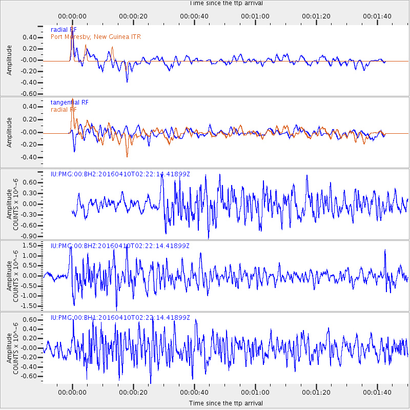
PMG Port Moresby, New Guinea - Earthquake Result Viewer
*The percent match for this event was below the threshold and hence no stack was calculated.
| Earthquake location: |
Southern Sumatra, Indonesia |
| Earthquake latitude/longitude: |
-4.1/102.3 |
| Earthquake time(UTC): |
2016/04/10 (101) 02:14:36 GMT |
| Earthquake Depth: |
55 km |
| Earthquake Magnitude: |
5.7 MWP |
| Earthquake Catalog/Contributor: |
NEIC PDE/NEIC COMCAT |
|
| Network: |
IU Global Seismograph Network (GSN - IRIS/USGS) |
| Station: |
PMG Port Moresby, New Guinea |
| Lat/Lon: |
9.40 S/147.16 E |
| Elevation: |
90 m |
|
| Distance: |
44.9 deg |
| Az: |
99.116 deg |
| Baz: |
273.568 deg |
| Ray Param: |
$rayparam |
*The percent match for this event was below the threshold and hence was not used in the summary stack. |
|
| Radial Match: |
69.557724 % |
| Radial Bump: |
400 |
| Transverse Match: |
69.46609 % |
| Transverse Bump: |
400 |
| SOD ConfigId: |
1475611 |
| Insert Time: |
2016-04-24 02:20:03.111 +0000 |
| GWidth: |
2.5 |
| Max Bumps: |
400 |
| Tol: |
0.001 |
|
Signal To Noise
| Channel | StoN | STA | LTA |
| IU:PMG:00:BHZ:20160410T02:22:14.41899Z | 6.854608 | 7.714386E-7 | 1.1254307E-7 |
| IU:PMG:00:BH1:20160410T02:22:14.41899Z | 1.6388144 | 2.2233546E-7 | 1.3566849E-7 |
| IU:PMG:00:BH2:20160410T02:22:14.41899Z | 2.9338582 | 4.5171834E-7 | 1.5396733E-7 |
| Arrivals |
| Ps | |
| PpPs | |
| PsPs/PpSs | |


