You are here: Home > Network List > TA - USArray Transportable Network (new EarthScope stations) Stations List
> Station 121A Cookes Peak, Deming, NM, USA > Earthquake Result Viewer
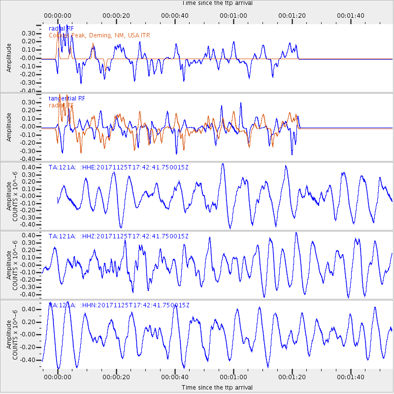
121A Cookes Peak, Deming, NM, USA - Earthquake Result Viewer
*The percent match for this event was below the threshold and hence no stack was calculated.
| Earthquake location: |
Vanuatu Islands Region |
| Earthquake latitude/longitude: |
-20.6/172.6 |
| Earthquake time(UTC): |
2017/11/25 (329) 17:30:01 GMT |
| Earthquake Depth: |
10 km |
| Earthquake Magnitude: |
5.8 Mww |
| Earthquake Catalog/Contributor: |
NEIC PDE/us |
|
| Network: |
TA USArray Transportable Network (new EarthScope stations) |
| Station: |
121A Cookes Peak, Deming, NM, USA |
| Lat/Lon: |
32.53 N/107.79 W |
| Elevation: |
1652 m |
|
| Distance: |
92.6 deg |
| Az: |
56.287 deg |
| Baz: |
247.281 deg |
| Ray Param: |
$rayparam |
*The percent match for this event was below the threshold and hence was not used in the summary stack. |
|
| Radial Match: |
33.260918 % |
| Radial Bump: |
400 |
| Transverse Match: |
62.64666 % |
| Transverse Bump: |
363 |
| SOD ConfigId: |
13570011 |
| Insert Time: |
2019-04-29 07:35:52.634 +0000 |
| GWidth: |
2.5 |
| Max Bumps: |
400 |
| Tol: |
0.001 |
|
Signal To Noise
| Channel | StoN | STA | LTA |
| TA:121A: :HHZ:20171125T17:42:41.750015Z | 1.1019762 | 1.4779921E-7 | 1.3412198E-7 |
| TA:121A: :HHN:20171125T17:42:41.750015Z | 2.027923 | 3.7853E-7 | 1.8665895E-7 |
| TA:121A: :HHE:20171125T17:42:41.750015Z | 0.5315251 | 9.390671E-8 | 1.766741E-7 |
| Arrivals |
| Ps | |
| PpPs | |
| PsPs/PpSs | |


