You are here: Home > Network List > AZ - ANZA Regional Network Stations List
> Station SMER AZ.SMER > Earthquake Result Viewer
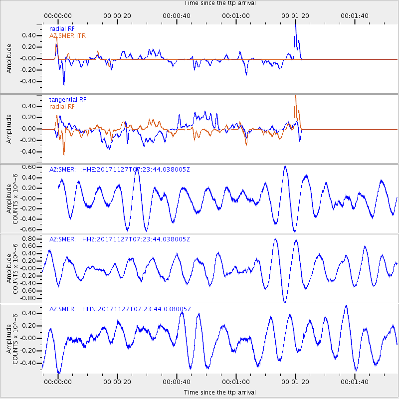
SMER AZ.SMER - Earthquake Result Viewer
*The percent match for this event was below the threshold and hence no stack was calculated.
| Earthquake location: |
New Ireland Region, P.N.G. |
| Earthquake latitude/longitude: |
-4.6/153.2 |
| Earthquake time(UTC): |
2017/11/27 (331) 07:11:12 GMT |
| Earthquake Depth: |
58 km |
| Earthquake Magnitude: |
6.0 Mww |
| Earthquake Catalog/Contributor: |
NEIC PDE/us |
|
| Network: |
AZ ANZA Regional Network |
| Station: |
SMER AZ.SMER |
| Lat/Lon: |
33.46 N/117.17 W |
| Elevation: |
355 m |
|
| Distance: |
92.2 deg |
| Az: |
56.781 deg |
| Baz: |
265.954 deg |
| Ray Param: |
$rayparam |
*The percent match for this event was below the threshold and hence was not used in the summary stack. |
|
| Radial Match: |
75.02408 % |
| Radial Bump: |
400 |
| Transverse Match: |
58.843933 % |
| Transverse Bump: |
400 |
| SOD ConfigId: |
13570011 |
| Insert Time: |
2019-04-29 07:38:36.853 +0000 |
| GWidth: |
2.5 |
| Max Bumps: |
400 |
| Tol: |
0.001 |
|
Signal To Noise
| Channel | StoN | STA | LTA |
| AZ:SMER: :HHZ:20171127T07:23:44.038005Z | 0.9457815 | 2.6062733E-7 | 2.755682E-7 |
| AZ:SMER: :HHN:20171127T07:23:44.038005Z | 1.1766863 | 3.7680832E-7 | 3.2022834E-7 |
| AZ:SMER: :HHE:20171127T07:23:44.038005Z | 1.2726969 | 3.021812E-7 | 2.3743377E-7 |
| Arrivals |
| Ps | |
| PpPs | |
| PsPs/PpSs | |


