You are here: Home > Network List > TA - USArray Transportable Network (new EarthScope stations) Stations List
> Station I17K Unalakleet, AK, USA > Earthquake Result Viewer
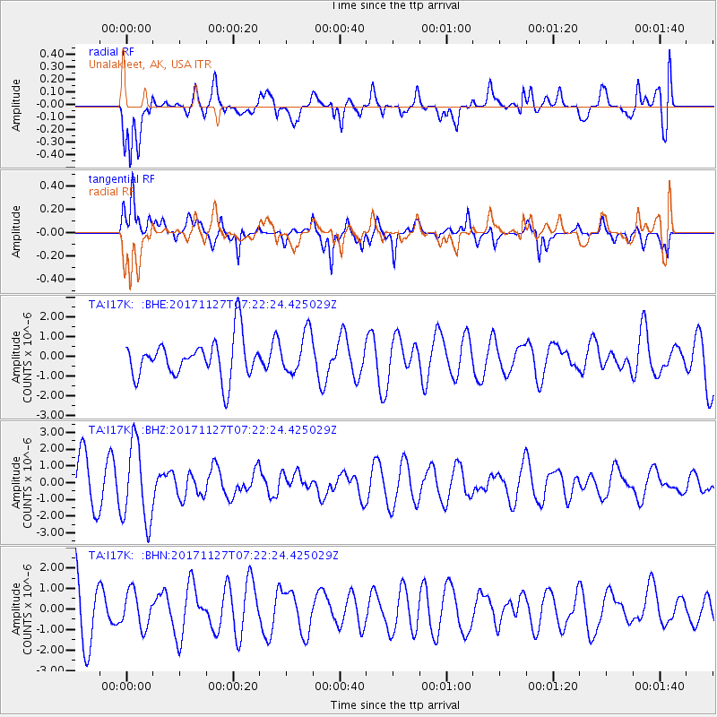
I17K Unalakleet, AK, USA - Earthquake Result Viewer
*The percent match for this event was below the threshold and hence no stack was calculated.
| Earthquake location: |
New Ireland Region, P.N.G. |
| Earthquake latitude/longitude: |
-4.6/153.2 |
| Earthquake time(UTC): |
2017/11/27 (331) 07:11:12 GMT |
| Earthquake Depth: |
58 km |
| Earthquake Magnitude: |
6.0 Mww |
| Earthquake Catalog/Contributor: |
NEIC PDE/us |
|
| Network: |
TA USArray Transportable Network (new EarthScope stations) |
| Station: |
I17K Unalakleet, AK, USA |
| Lat/Lon: |
63.89 N/160.70 W |
| Elevation: |
105 m |
|
| Distance: |
76.5 deg |
| Az: |
19.145 deg |
| Baz: |
227.622 deg |
| Ray Param: |
$rayparam |
*The percent match for this event was below the threshold and hence was not used in the summary stack. |
|
| Radial Match: |
58.1484 % |
| Radial Bump: |
400 |
| Transverse Match: |
59.68959 % |
| Transverse Bump: |
400 |
| SOD ConfigId: |
13570011 |
| Insert Time: |
2019-04-29 07:42:06.850 +0000 |
| GWidth: |
2.5 |
| Max Bumps: |
400 |
| Tol: |
0.001 |
|
Signal To Noise
| Channel | StoN | STA | LTA |
| TA:I17K: :BHZ:20171127T07:22:24.425029Z | 1.8012998 | 2.3677835E-6 | 1.3144861E-6 |
| TA:I17K: :BHN:20171127T07:22:24.425029Z | 0.57820046 | 8.782256E-7 | 1.5188948E-6 |
| TA:I17K: :BHE:20171127T07:22:24.425029Z | 1.0612812 | 1.042379E-6 | 9.821892E-7 |
| Arrivals |
| Ps | |
| PpPs | |
| PsPs/PpSs | |


