You are here: Home > Network List > TA - USArray Transportable Network (new EarthScope stations) Stations List
> Station M31M Drury Creek, Yukon, CA > Earthquake Result Viewer
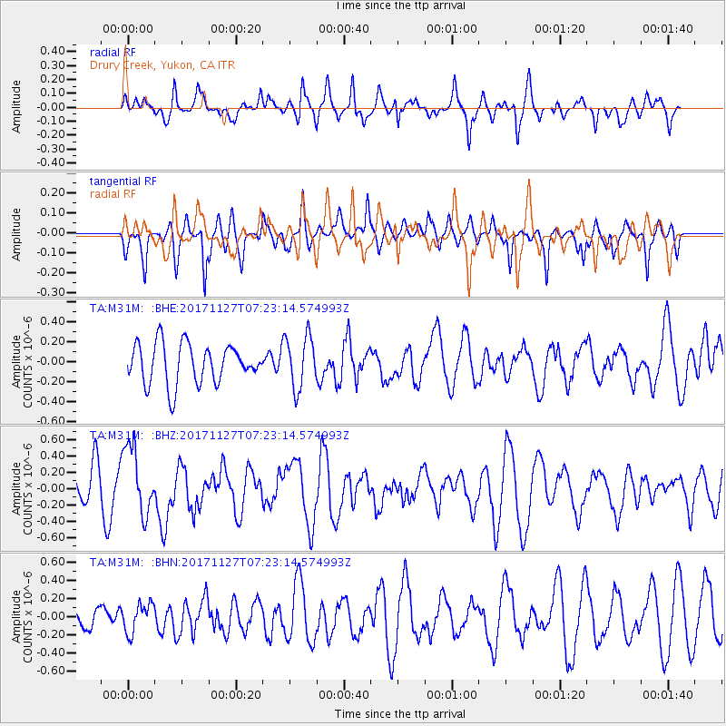
M31M Drury Creek, Yukon, CA - Earthquake Result Viewer
*The percent match for this event was below the threshold and hence no stack was calculated.
| Earthquake location: |
New Ireland Region, P.N.G. |
| Earthquake latitude/longitude: |
-4.6/153.2 |
| Earthquake time(UTC): |
2017/11/27 (331) 07:11:12 GMT |
| Earthquake Depth: |
58 km |
| Earthquake Magnitude: |
6.0 Mww |
| Earthquake Catalog/Contributor: |
NEIC PDE/us |
|
| Network: |
TA USArray Transportable Network (new EarthScope stations) |
| Station: |
M31M Drury Creek, Yukon, CA |
| Lat/Lon: |
62.20 N/134.39 W |
| Elevation: |
639 m |
|
| Distance: |
85.9 deg |
| Az: |
26.614 deg |
| Baz: |
252.272 deg |
| Ray Param: |
$rayparam |
*The percent match for this event was below the threshold and hence was not used in the summary stack. |
|
| Radial Match: |
68.90155 % |
| Radial Bump: |
390 |
| Transverse Match: |
60.10675 % |
| Transverse Bump: |
332 |
| SOD ConfigId: |
13570011 |
| Insert Time: |
2019-04-29 07:42:16.372 +0000 |
| GWidth: |
2.5 |
| Max Bumps: |
400 |
| Tol: |
0.001 |
|
Signal To Noise
| Channel | StoN | STA | LTA |
| TA:M31M: :BHZ:20171127T07:23:14.574993Z | 1.8994752 | 4.1776687E-7 | 2.1993804E-7 |
| TA:M31M: :BHN:20171127T07:23:14.574993Z | 0.60541534 | 1.6149222E-7 | 2.6674618E-7 |
| TA:M31M: :BHE:20171127T07:23:14.574993Z | 1.2777873 | 2.548232E-7 | 1.9942536E-7 |
| Arrivals |
| Ps | |
| PpPs | |
| PsPs/PpSs | |


