You are here: Home > Network List > TA - USArray Transportable Network (new EarthScope stations) Stations List
> Station R32K Eaglecrest, AK, USA > Earthquake Result Viewer
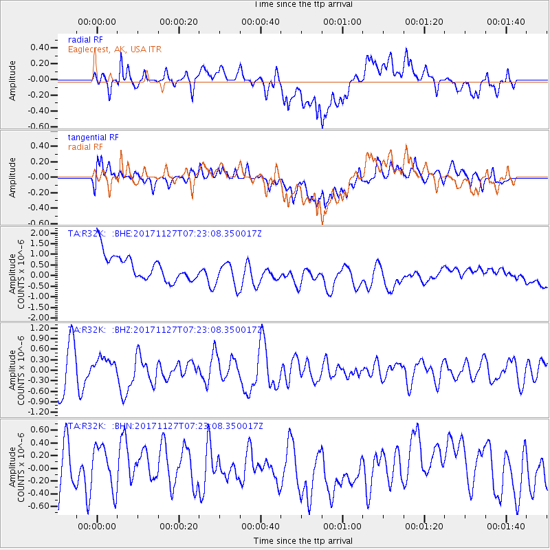
R32K Eaglecrest, AK, USA - Earthquake Result Viewer
*The percent match for this event was below the threshold and hence no stack was calculated.
| Earthquake location: |
New Ireland Region, P.N.G. |
| Earthquake latitude/longitude: |
-4.6/153.2 |
| Earthquake time(UTC): |
2017/11/27 (331) 07:11:12 GMT |
| Earthquake Depth: |
58 km |
| Earthquake Magnitude: |
6.0 Mww |
| Earthquake Catalog/Contributor: |
NEIC PDE/us |
|
| Network: |
TA USArray Transportable Network (new EarthScope stations) |
| Station: |
R32K Eaglecrest, AK, USA |
| Lat/Lon: |
58.27 N/134.52 W |
| Elevation: |
386 m |
|
| Distance: |
84.7 deg |
| Az: |
30.363 deg |
| Baz: |
252.467 deg |
| Ray Param: |
$rayparam |
*The percent match for this event was below the threshold and hence was not used in the summary stack. |
|
| Radial Match: |
48.241276 % |
| Radial Bump: |
400 |
| Transverse Match: |
48.93197 % |
| Transverse Bump: |
400 |
| SOD ConfigId: |
13570011 |
| Insert Time: |
2019-04-29 07:42:27.940 +0000 |
| GWidth: |
2.5 |
| Max Bumps: |
400 |
| Tol: |
0.001 |
|
Signal To Noise
| Channel | StoN | STA | LTA |
| TA:R32K: :BHZ:20171127T07:23:08.350017Z | 0.59076935 | 2.7671175E-7 | 4.683922E-7 |
| TA:R32K: :BHN:20171127T07:23:08.350017Z | 1.4063846 | 3.8322034E-7 | 2.7248615E-7 |
| TA:R32K: :BHE:20171127T07:23:08.350017Z | 1.1333697 | 6.3380094E-7 | 5.5921817E-7 |
| Arrivals |
| Ps | |
| PpPs | |
| PsPs/PpSs | |


