You are here: Home > Network List > TA - USArray Transportable Network (new EarthScope stations) Stations List
> Station A12A Yaak River Ranch, Troy, MT, USA > Earthquake Result Viewer
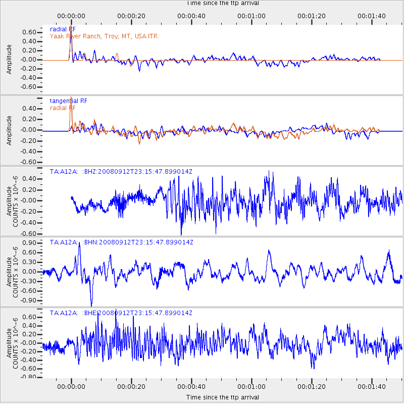
A12A Yaak River Ranch, Troy, MT, USA - Earthquake Result Viewer
*The percent match for this event was below the threshold and hence no stack was calculated.
| Earthquake location: |
Komandorskiye Ostrova Region |
| Earthquake latitude/longitude: |
56.3/164.1 |
| Earthquake time(UTC): |
2008/09/12 (256) 23:07:50 GMT |
| Earthquake Depth: |
9.3 km |
| Earthquake Magnitude: |
5.5 MB, 5.7 MS, 5.9 MW, 5.9 MW |
| Earthquake Catalog/Contributor: |
WHDF/NEIC |
|
| Network: |
TA USArray Transportable Network (new EarthScope stations) |
| Station: |
A12A Yaak River Ranch, Troy, MT, USA |
| Lat/Lon: |
48.93 N/115.65 W |
| Elevation: |
928 m |
|
| Distance: |
46.7 deg |
| Az: |
63.338 deg |
| Baz: |
310.948 deg |
| Ray Param: |
$rayparam |
*The percent match for this event was below the threshold and hence was not used in the summary stack. |
|
| Radial Match: |
65.74967 % |
| Radial Bump: |
400 |
| Transverse Match: |
49.0537 % |
| Transverse Bump: |
400 |
| SOD ConfigId: |
2560 |
| Insert Time: |
2010-03-06 06:58:36.594 +0000 |
| GWidth: |
2.5 |
| Max Bumps: |
400 |
| Tol: |
0.001 |
|
Signal To Noise
| Channel | StoN | STA | LTA |
| TA:A12A: :BHN:20080912T23:15:47.899014Z | 4.586839 | 3.2657235E-7 | 7.119769E-8 |
| TA:A12A: :BHE:20080912T23:15:47.899014Z | 1.7929834 | 1.8985891E-7 | 1.05889946E-7 |
| TA:A12A: :BHZ:20080912T23:15:47.899014Z | 2.1429873 | 2.2994988E-7 | 1.0730343E-7 |
| Arrivals |
| Ps | |
| PpPs | |
| PsPs/PpSs | |


