You are here: Home > Network List > TA - USArray Transportable Network (new EarthScope stations) Stations List
> Station A12A Yaak River Ranch, Troy, MT, USA > Earthquake Result Viewer
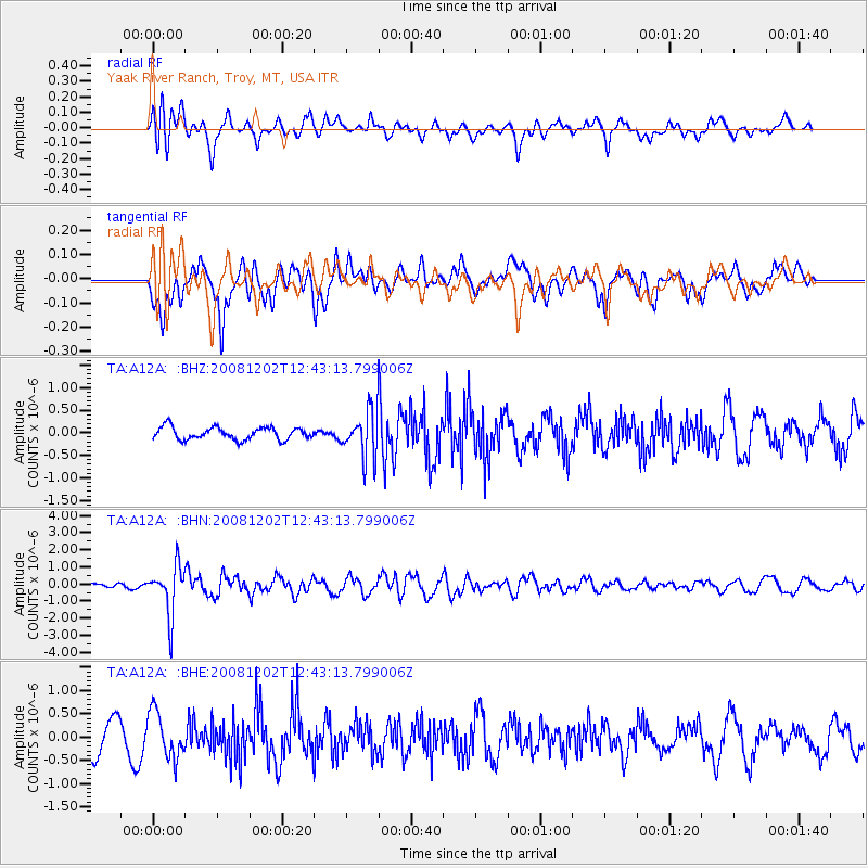
A12A Yaak River Ranch, Troy, MT, USA - Earthquake Result Viewer
*The percent match for this event was below the threshold and hence no stack was calculated.
| Earthquake location: |
Mariana Islands |
| Earthquake latitude/longitude: |
19.1/145.8 |
| Earthquake time(UTC): |
2008/12/02 (337) 12:31:43 GMT |
| Earthquake Depth: |
137 km |
| Earthquake Magnitude: |
5.9 MB, 5.9 MW, 5.9 MW |
| Earthquake Catalog/Contributor: |
WHDF/NEIC |
|
| Network: |
TA USArray Transportable Network (new EarthScope stations) |
| Station: |
A12A Yaak River Ranch, Troy, MT, USA |
| Lat/Lon: |
48.93 N/115.65 W |
| Elevation: |
928 m |
|
| Distance: |
81.3 deg |
| Az: |
41.272 deg |
| Baz: |
288.94 deg |
| Ray Param: |
$rayparam |
*The percent match for this event was below the threshold and hence was not used in the summary stack. |
|
| Radial Match: |
61.98526 % |
| Radial Bump: |
400 |
| Transverse Match: |
50.35345 % |
| Transverse Bump: |
400 |
| SOD ConfigId: |
2658 |
| Insert Time: |
2010-03-06 06:58:54.791 +0000 |
| GWidth: |
2.5 |
| Max Bumps: |
400 |
| Tol: |
0.001 |
|
Signal To Noise
| Channel | StoN | STA | LTA |
| TA:A12A: :BHN:20081202T12:43:13.799006Z | 7.1581235 | 1.4317371E-6 | 2.000157E-7 |
| TA:A12A: :BHE:20081202T12:43:13.799006Z | 1.8095741 | 4.925032E-7 | 2.7216527E-7 |
| TA:A12A: :BHZ:20081202T12:43:13.799006Z | 3.800998 | 5.1389986E-7 | 1.3520129E-7 |
| Arrivals |
| Ps | |
| PpPs | |
| PsPs/PpSs | |


