You are here: Home > Network List > TA - USArray Transportable Network (new EarthScope stations) Stations List
> Station A12A Yaak River Ranch, Troy, MT, USA > Earthquake Result Viewer
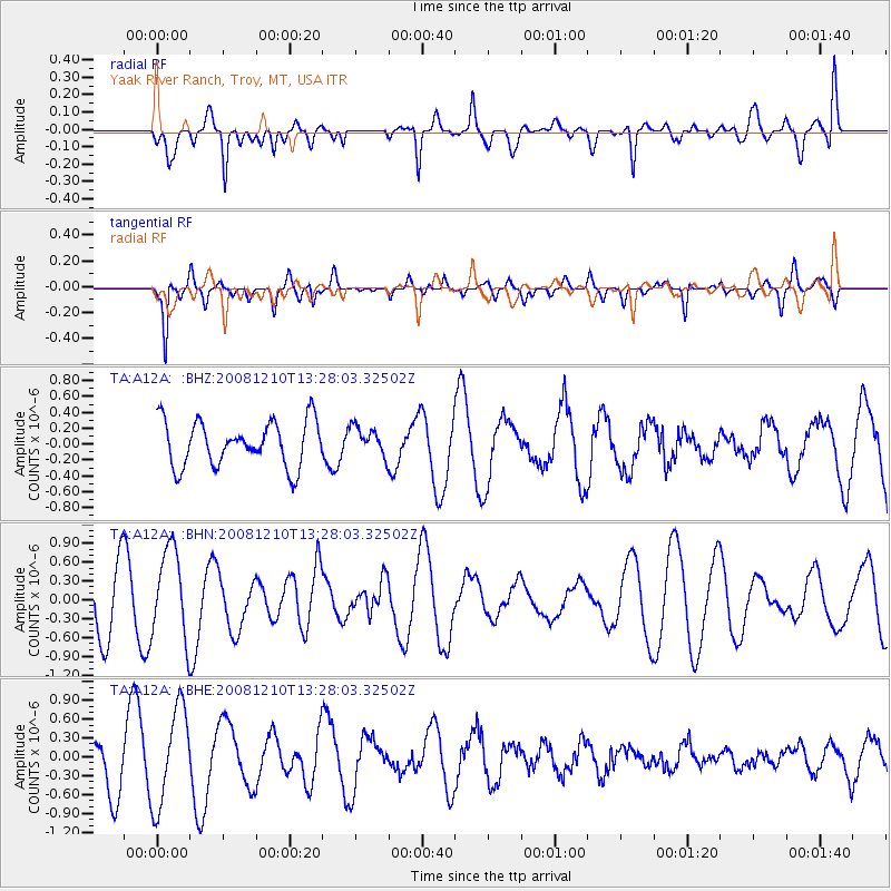
A12A Yaak River Ranch, Troy, MT, USA - Earthquake Result Viewer
*The percent match for this event was below the threshold and hence no stack was calculated.
| Earthquake location: |
Santa Cruz Islands |
| Earthquake latitude/longitude: |
-12.3/166.6 |
| Earthquake time(UTC): |
2008/12/10 (345) 13:15:34 GMT |
| Earthquake Depth: |
51 km |
| Earthquake Magnitude: |
5.7 MB, 6.0 MW, 6.0 MW |
| Earthquake Catalog/Contributor: |
WHDF/NEIC |
|
| Network: |
TA USArray Transportable Network (new EarthScope stations) |
| Station: |
A12A Yaak River Ranch, Troy, MT, USA |
| Lat/Lon: |
48.93 N/115.65 W |
| Elevation: |
928 m |
|
| Distance: |
91.3 deg |
| Az: |
40.14 deg |
| Baz: |
252.805 deg |
| Ray Param: |
$rayparam |
*The percent match for this event was below the threshold and hence was not used in the summary stack. |
|
| Radial Match: |
66.090065 % |
| Radial Bump: |
400 |
| Transverse Match: |
73.371445 % |
| Transverse Bump: |
360 |
| SOD ConfigId: |
2658 |
| Insert Time: |
2010-03-06 06:59:02.209 +0000 |
| GWidth: |
2.5 |
| Max Bumps: |
400 |
| Tol: |
0.001 |
|
Signal To Noise
| Channel | StoN | STA | LTA |
| TA:A12A: :BHN:20081210T13:28:03.32502Z | 1.6697913 | 7.0835875E-7 | 4.242199E-7 |
| TA:A12A: :BHE:20081210T13:28:03.32502Z | 2.6777508 | 7.8013596E-7 | 2.9134E-7 |
| TA:A12A: :BHZ:20081210T13:28:03.32502Z | 0.6430364 | 1.8280465E-7 | 2.8428352E-7 |
| Arrivals |
| Ps | |
| PpPs | |
| PsPs/PpSs | |


