You are here: Home > Network List > G - GEOSCOPE Stations List
> Station CLF Chambon la Foret observatory, France > Earthquake Result Viewer
CLF Chambon la Foret observatory, France - Earthquake Result Viewer
| Earthquake location: |
Afghanistan-Tajikistan Bord Reg. |
| Earthquake latitude/longitude: |
36.5/71.2 |
| Earthquake time(UTC): |
2016/04/10 (101) 10:28:58 GMT |
| Earthquake Depth: |
210 km |
| Earthquake Magnitude: |
6.6 MWB |
| Earthquake Catalog/Contributor: |
NEIC PDE/NEIC COMCAT |
|
| Network: |
G GEOSCOPE |
| Station: |
CLF Chambon la Foret observatory, France |
| Lat/Lon: |
48.03 N/2.26 E |
| Elevation: |
145 m |
|
| Distance: |
50.7 deg |
| Az: |
305.951 deg |
| Baz: |
76.361 deg |
| Ray Param: |
0.06713702 |
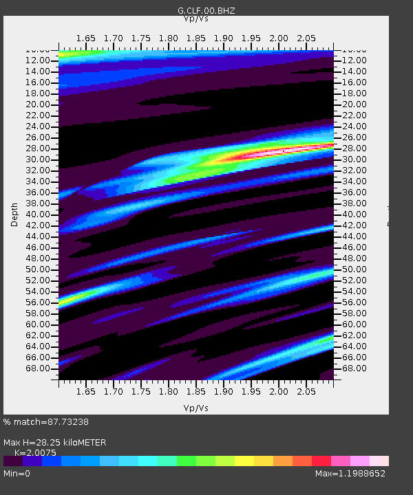
| Estimated Moho Depth: |
28.25 km |
| Estimated Crust Vp/Vs: |
2.01 |
| Assumed Crust Vp: |
6.12 km/s |
| Estimated Crust Vs: |
3.049 km/s |
| Estimated Crust Poisson's Ratio: |
0.33 |
|
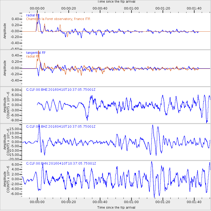
| Radial Match: |
87.73238 % |
| Radial Bump: |
351 |
| Transverse Match: |
67.50653 % |
| Transverse Bump: |
322 |
| SOD ConfigId: |
1475611 |
| Insert Time: |
2016-04-24 10:32:28.289 +0000 |
| GWidth: |
2.5 |
| Max Bumps: |
400 |
| Tol: |
0.001 |
|
Signal To Noise
| Channel | StoN | STA | LTA |
| G:CLF:00:BHZ:20160410T10:37:05.75001Z | 6.183146 | 8.80505E-6 | 1.4240404E-6 |
| G:CLF:00:BHN:20160410T10:37:05.75001Z | 3.2276657 | 3.4166617E-6 | 1.058555E-6 |
| G:CLF:00:BHE:20160410T10:37:05.75001Z | 2.7796884 | 4.3860587E-6 | 1.5778958E-6 |
| Arrivals |
| Ps | 4.9 SECOND |
| PpPs | 13 SECOND |
| PsPs/PpSs | 18 SECOND |


