You are here: Home > Network List > TA - USArray Transportable Network (new EarthScope stations) Stations List
> Station BGNE Belgrade, NE, USA > Earthquake Result Viewer
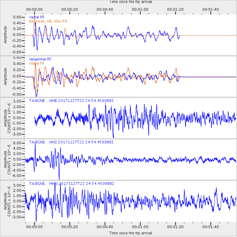
BGNE Belgrade, NE, USA - Earthquake Result Viewer
*The percent match for this event was below the threshold and hence no stack was calculated.
| Earthquake location: |
Southern Alaska |
| Earthquake latitude/longitude: |
60.6/-147.4 |
| Earthquake time(UTC): |
2017/11/27 (331) 22:18:30 GMT |
| Earthquake Depth: |
16 km |
| Earthquake Magnitude: |
5.5 Mww |
| Earthquake Catalog/Contributor: |
NEIC PDE/ak |
|
| Network: |
TA USArray Transportable Network (new EarthScope stations) |
| Station: |
BGNE Belgrade, NE, USA |
| Lat/Lon: |
41.41 N/98.15 W |
| Elevation: |
573 m |
|
| Distance: |
35.4 deg |
| Az: |
100.075 deg |
| Baz: |
319.718 deg |
| Ray Param: |
$rayparam |
*The percent match for this event was below the threshold and hence was not used in the summary stack. |
|
| Radial Match: |
63.149803 % |
| Radial Bump: |
400 |
| Transverse Match: |
74.46535 % |
| Transverse Bump: |
400 |
| SOD ConfigId: |
13570011 |
| Insert Time: |
2019-04-29 07:49:17.310 +0000 |
| GWidth: |
2.5 |
| Max Bumps: |
400 |
| Tol: |
0.001 |
|
Signal To Noise
| Channel | StoN | STA | LTA |
| TA:BGNE: :HHZ:20171127T22:24:54.459988Z | 3.4202797 | 1.727026E-6 | 5.04937E-7 |
| TA:BGNE: :HHN:20171127T22:24:54.459988Z | 1.6484808 | 1.2271782E-6 | 7.444298E-7 |
| TA:BGNE: :HHE:20171127T22:24:54.459988Z | 1.7920429 | 1.0751514E-6 | 5.999585E-7 |
| Arrivals |
| Ps | |
| PpPs | |
| PsPs/PpSs | |


