You are here: Home > Network List > TA - USArray Transportable Network (new EarthScope stations) Stations List
> Station MSTX Muleshoe, TX, USA > Earthquake Result Viewer
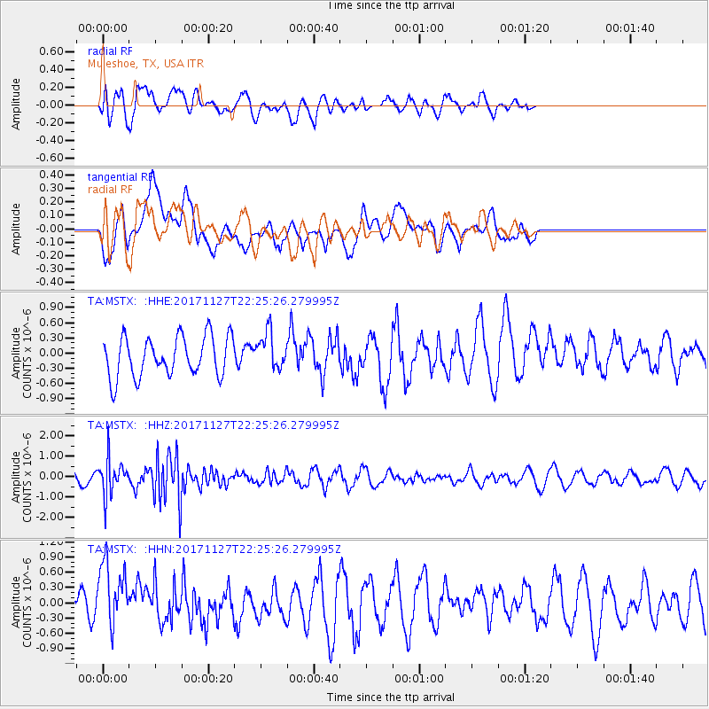
MSTX Muleshoe, TX, USA - Earthquake Result Viewer
*The percent match for this event was below the threshold and hence no stack was calculated.
| Earthquake location: |
Southern Alaska |
| Earthquake latitude/longitude: |
60.6/-147.4 |
| Earthquake time(UTC): |
2017/11/27 (331) 22:18:30 GMT |
| Earthquake Depth: |
16 km |
| Earthquake Magnitude: |
5.5 Mww |
| Earthquake Catalog/Contributor: |
NEIC PDE/ak |
|
| Network: |
TA USArray Transportable Network (new EarthScope stations) |
| Station: |
MSTX Muleshoe, TX, USA |
| Lat/Lon: |
33.97 N/102.77 W |
| Elevation: |
1167 m |
|
| Distance: |
39.1 deg |
| Az: |
112.286 deg |
| Baz: |
326.635 deg |
| Ray Param: |
$rayparam |
*The percent match for this event was below the threshold and hence was not used in the summary stack. |
|
| Radial Match: |
58.55623 % |
| Radial Bump: |
400 |
| Transverse Match: |
64.68671 % |
| Transverse Bump: |
400 |
| SOD ConfigId: |
13570011 |
| Insert Time: |
2019-04-29 07:49:20.231 +0000 |
| GWidth: |
2.5 |
| Max Bumps: |
400 |
| Tol: |
0.001 |
|
Signal To Noise
| Channel | StoN | STA | LTA |
| TA:MSTX: :HHZ:20171127T22:25:26.279995Z | 3.7430174 | 8.803134E-7 | 2.3518817E-7 |
| TA:MSTX: :HHN:20171127T22:25:26.279995Z | 2.292462 | 6.922173E-7 | 3.0195366E-7 |
| TA:MSTX: :HHE:20171127T22:25:26.279995Z | 0.9302473 | 3.6563554E-7 | 3.9305198E-7 |
| Arrivals |
| Ps | |
| PpPs | |
| PsPs/PpSs | |


