You are here: Home > Network List > TA - USArray Transportable Network (new EarthScope stations) Stations List
> Station SFIN Lafayette, IN, USA > Earthquake Result Viewer
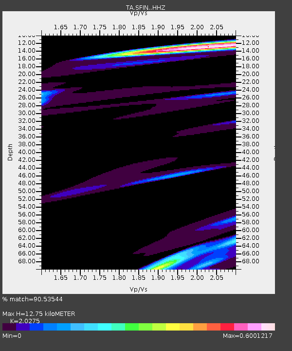
SFIN Lafayette, IN, USA - Earthquake Result Viewer
| Earthquake location: |
Norwegian Sea |
| Earthquake latitude/longitude: |
72.6/3.2 |
| Earthquake time(UTC): |
2017/11/28 (332) 13:15:46 GMT |
| Earthquake Depth: |
10 km |
| Earthquake Magnitude: |
5.6 Mww |
| Earthquake Catalog/Contributor: |
NEIC PDE/us |
|
| Network: |
TA USArray Transportable Network (new EarthScope stations) |
| Station: |
SFIN Lafayette, IN, USA |
| Lat/Lon: |
40.38 N/87.10 W |
| Elevation: |
165 m |
|
| Distance: |
52.1 deg |
| Az: |
284.513 deg |
| Baz: |
22.419 deg |
| Ray Param: |
0.066976234 |
| Estimated Moho Depth: |
12.75 km |
| Estimated Crust Vp/Vs: |
2.03 |
| Assumed Crust Vp: |
6.498 km/s |
| Estimated Crust Vs: |
3.205 km/s |
| Estimated Crust Poisson's Ratio: |
0.34 |
|
| Radial Match: |
90.53544 % |
| Radial Bump: |
400 |
| Transverse Match: |
58.778175 % |
| Transverse Bump: |
310 |
| SOD ConfigId: |
13570011 |
| Insert Time: |
2019-04-29 07:57:31.040 +0000 |
| GWidth: |
2.5 |
| Max Bumps: |
400 |
| Tol: |
0.001 |
|

Signal To Noise
| Channel | StoN | STA | LTA |
| TA:SFIN: :HHZ:20171128T13:24:24.74001Z | 1.7262491 | 3.4127443E-6 | 1.976971E-6 |
| TA:SFIN: :HHN:20171128T13:24:24.74001Z | 1.2790006 | 2.58966E-6 | 2.0247526E-6 |
| TA:SFIN: :HHE:20171128T13:24:24.74001Z | 1.718594 | 1.1132106E-6 | 6.4774497E-7 |
| Arrivals |
| Ps | 2.1 SECOND |
| PpPs | 5.7 SECOND |
| PsPs/PpSs | 7.8 SECOND |


