You are here: Home > Network List > UW - Pacific Northwest Regional Seismic Network Stations List
> Station MRBL Marblemount, WA, USA > Earthquake Result Viewer
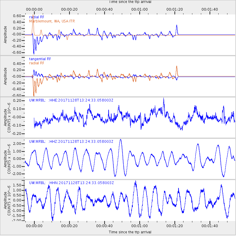
MRBL Marblemount, WA, USA - Earthquake Result Viewer
*The percent match for this event was below the threshold and hence no stack was calculated.
| Earthquake location: |
Norwegian Sea |
| Earthquake latitude/longitude: |
72.6/3.2 |
| Earthquake time(UTC): |
2017/11/28 (332) 13:15:46 GMT |
| Earthquake Depth: |
10 km |
| Earthquake Magnitude: |
5.6 Mww |
| Earthquake Catalog/Contributor: |
NEIC PDE/us |
|
| Network: |
UW Pacific Northwest Regional Seismic Network |
| Station: |
MRBL Marblemount, WA, USA |
| Lat/Lon: |
48.52 N/121.48 W |
| Elevation: |
75 m |
|
| Distance: |
53.2 deg |
| Az: |
316.952 deg |
| Baz: |
17.998 deg |
| Ray Param: |
$rayparam |
*The percent match for this event was below the threshold and hence was not used in the summary stack. |
|
| Radial Match: |
68.95235 % |
| Radial Bump: |
400 |
| Transverse Match: |
66.69908 % |
| Transverse Bump: |
400 |
| SOD ConfigId: |
13570011 |
| Insert Time: |
2019-04-29 07:58:32.432 +0000 |
| GWidth: |
2.5 |
| Max Bumps: |
400 |
| Tol: |
0.001 |
|
Signal To Noise
| Channel | StoN | STA | LTA |
| UW:MRBL: :HHZ:20171128T13:24:33.058003Z | 1.4419736 | 9.589016E-7 | 6.649925E-7 |
| UW:MRBL: :HHN:20171128T13:24:33.058003Z | 0.7472978 | 3.8960746E-7 | 5.21355E-7 |
| UW:MRBL: :HHE:20171128T13:24:33.058003Z | 1.8395659 | 7.5283594E-8 | 4.0924654E-8 |
| Arrivals |
| Ps | |
| PpPs | |
| PsPs/PpSs | |


