You are here: Home > Network List > TA - USArray Transportable Network (new EarthScope stations) Stations List
> Station O21A Pagoda, CO, USA > Earthquake Result Viewer
O21A Pagoda, CO, USA - Earthquake Result Viewer
| Earthquake location: |
Andreanof Islands, Aleutian Is. |
| Earthquake latitude/longitude: |
51.4/-179.0 |
| Earthquake time(UTC): |
2007/12/21 (355) 07:24:34 GMT |
| Earthquake Depth: |
30 km |
| Earthquake Magnitude: |
6.1 MB, 6.2 MW, 6.3 ML |
| Earthquake Catalog/Contributor: |
WHDF/NEIC |
|
| Network: |
TA USArray Transportable Network (new EarthScope stations) |
| Station: |
O21A Pagoda, CO, USA |
| Lat/Lon: |
40.21 N/107.47 W |
| Elevation: |
2343 m |
|
| Distance: |
49.2 deg |
| Az: |
73.58 deg |
| Baz: |
308.243 deg |
| Ray Param: |
0.06879264 |
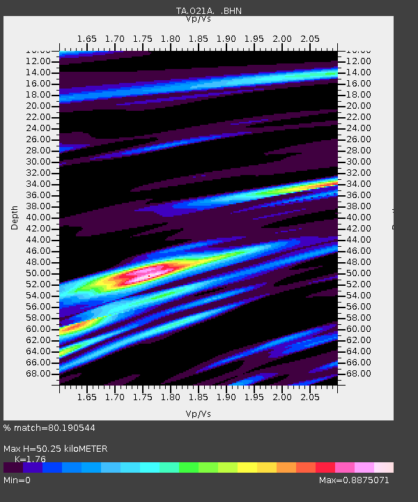
| Estimated Moho Depth: |
50.25 km |
| Estimated Crust Vp/Vs: |
1.76 |
| Assumed Crust Vp: |
6.159 km/s |
| Estimated Crust Vs: |
3.499 km/s |
| Estimated Crust Poisson's Ratio: |
0.26 |
|
| Radial Match: |
80.190544 % |
| Radial Bump: |
400 |
| Transverse Match: |
61.092205 % |
| Transverse Bump: |
400 |
| SOD ConfigId: |
2564 |
| Insert Time: |
2010-03-06 06:59:37.293 +0000 |
| GWidth: |
2.5 |
| Max Bumps: |
400 |
| Tol: |
0.001 |
|

Signal To Noise
| Channel | StoN | STA | LTA |
| TA:O21A: :BHN:20071221T07:32:49.525004Z | 1.9187101 | 7.352512E-7 | 3.8320078E-7 |
| TA:O21A: :BHE:20071221T07:32:49.525004Z | 2.8579118 | 1.1205061E-6 | 3.9207163E-7 |
| TA:O21A: :BHZ:20071221T07:32:49.525004Z | 6.8182745 | 2.1151043E-6 | 3.1021105E-7 |
| Arrivals |
| Ps | 6.5 SECOND |
| PpPs | 21 SECOND |
| PsPs/PpSs | 28 SECOND |


