You are here: Home > Network List > TA - USArray Transportable Network (new EarthScope stations) Stations List
> Station O21A Pagoda, CO, USA > Earthquake Result Viewer
O21A Pagoda, CO, USA - Earthquake Result Viewer
| Earthquake location: |
Kuril Islands |
| Earthquake latitude/longitude: |
49.9/156.4 |
| Earthquake time(UTC): |
2008/08/04 (217) 04:42:14 GMT |
| Earthquake Depth: |
77 km |
| Earthquake Magnitude: |
5.6 MB, 5.8 MW, 5.7 MW |
| Earthquake Catalog/Contributor: |
WHDF/NEIC |
|
| Network: |
TA USArray Transportable Network (new EarthScope stations) |
| Station: |
O21A Pagoda, CO, USA |
| Lat/Lon: |
40.21 N/107.47 W |
| Elevation: |
2343 m |
|
| Distance: |
64.1 deg |
| Az: |
57.834 deg |
| Baz: |
314.312 deg |
| Ray Param: |
0.058961425 |
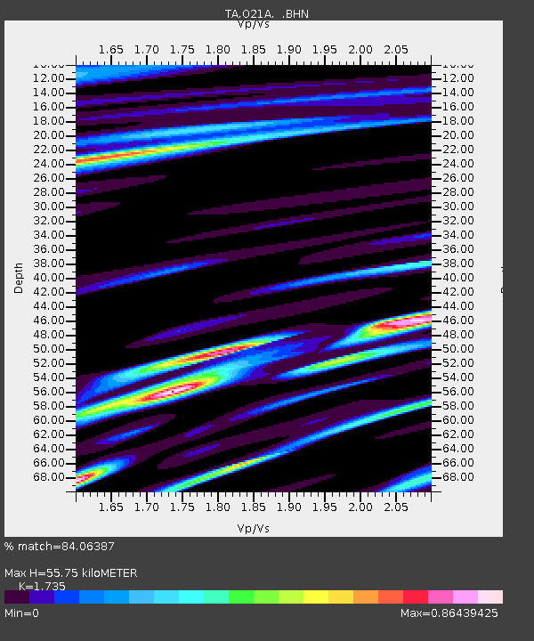
| Estimated Moho Depth: |
55.75 km |
| Estimated Crust Vp/Vs: |
1.74 |
| Assumed Crust Vp: |
6.159 km/s |
| Estimated Crust Vs: |
3.55 km/s |
| Estimated Crust Poisson's Ratio: |
0.25 |
|
| Radial Match: |
84.06387 % |
| Radial Bump: |
400 |
| Transverse Match: |
69.94811 % |
| Transverse Bump: |
400 |
| SOD ConfigId: |
2504 |
| Insert Time: |
2010-03-06 07:00:09.994 +0000 |
| GWidth: |
2.5 |
| Max Bumps: |
400 |
| Tol: |
0.001 |
|

Signal To Noise
| Channel | StoN | STA | LTA |
| TA:O21A: :BHN:20080804T04:52:09.975Z | 8.932071 | 5.103621E-7 | 5.7138163E-8 |
| TA:O21A: :BHE:20080804T04:52:09.975Z | 1.9867096 | 1.5581323E-7 | 7.842778E-8 |
| TA:O21A: :BHZ:20080804T04:52:09.975Z | 1.8700126 | 1.8163433E-7 | 9.7130005E-8 |
| Arrivals |
| Ps | 6.9 SECOND |
| PpPs | 24 SECOND |
| PsPs/PpSs | 31 SECOND |


