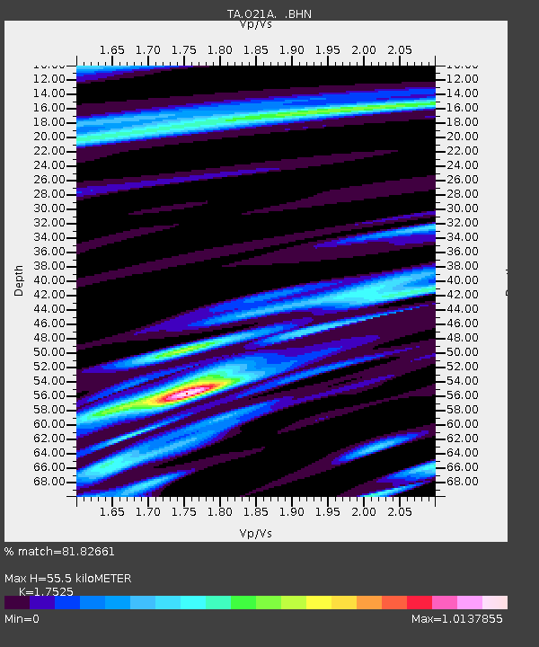
O21A Pagoda, CO, USA - Earthquake Result Viewer

Earthquake location: Andreanof Islands, Aleutian Is.
Earthquake latitude/longitude: 52.2/-175.7
Earthquake time(UTC): 2008/08/07 (220) 18:30:03 GMT
Earthquake Depth: 12 km
Earthquake Magnitude: 5.6 MB, 5.5 MS, 5.8 MW, 5.8 MW
Earthquake Catalog/Contributor: WHDF/NEIC
Network: TA USArray Transportable Network (new EarthScope stations)
Station: O21A Pagoda, CO, USA
Lat/Lon: 40.21 N/107.47 W
Elevation: 2343 m
Distance: 47.0 deg
Az: 76.428 deg
Baz: 308.604 deg
Ray Param: 0.070277885
Estimated Moho Depth: 55.5 km
Estimated Crust Vp/Vs: 1.75
Assumed Crust Vp: 6.159 km/s
Estimated Crust Vs: 3.514 km/s
Estimated Crust Poisson's Ratio: 0.26
Radial Match: 81.82661 %
Radial Bump: 400
Transverse Match: 66.49788 %
Transverse Bump: 400
SOD ConfigId: 2504
Insert Time: 2010-03-06 07:00:13.003 +0000
GWidth: 2.5
Max Bumps: 400
Tol: 0.001

Signal To Noise

ChannelStoNSTALTA
TA:O21A: :BHN:20080807T18:38:03.050011Z8.822575.0638886E-75.739698E-8
TA:O21A: :BHE:20080807T18:38:03.050011Z2.33987571.4666605E-76.268113E-8
TA:O21A: :BHZ:20080807T18:38:03.050011Z2.8524762.1908332E-77.680462E-8
Arrivals
Ps7.2 SECOND
PpPs23 SECOND
PsPs/PpSs31 SECOND