You are here: Home > Network List > IU - Global Seismograph Network (GSN - IRIS/USGS) Stations List
> Station FURI Mt. Furi, Ethiopia > Earthquake Result Viewer
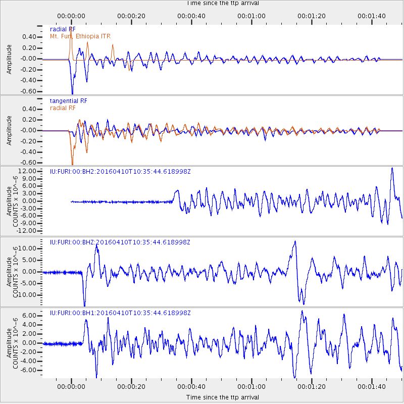
FURI Mt. Furi, Ethiopia - Earthquake Result Viewer
*The percent match for this event was below the threshold and hence no stack was calculated.
| Earthquake location: |
Afghanistan-Tajikistan Bord Reg. |
| Earthquake latitude/longitude: |
36.5/71.2 |
| Earthquake time(UTC): |
2016/04/10 (101) 10:28:58 GMT |
| Earthquake Depth: |
210 km |
| Earthquake Magnitude: |
6.6 MWB |
| Earthquake Catalog/Contributor: |
NEIC PDE/NEIC COMCAT |
|
| Network: |
IU Global Seismograph Network (GSN - IRIS/USGS) |
| Station: |
FURI Mt. Furi, Ethiopia |
| Lat/Lon: |
8.90 N/38.68 E |
| Elevation: |
2570 m |
|
| Distance: |
40.3 deg |
| Az: |
235.124 deg |
| Baz: |
41.994 deg |
| Ray Param: |
$rayparam |
*The percent match for this event was below the threshold and hence was not used in the summary stack. |
|
| Radial Match: |
88.1233 % |
| Radial Bump: |
400 |
| Transverse Match: |
72.79514 % |
| Transverse Bump: |
400 |
| SOD ConfigId: |
1475611 |
| Insert Time: |
2016-04-24 10:37:16.215 +0000 |
| GWidth: |
2.5 |
| Max Bumps: |
400 |
| Tol: |
0.001 |
|
Signal To Noise
| Channel | StoN | STA | LTA |
| IU:FURI:00:BHZ:20160410T10:35:44.618998Z | 24.40637 | 4.9159116E-6 | 2.014192E-7 |
| IU:FURI:00:BH1:20160410T10:35:44.618998Z | 8.739828 | 1.5731257E-6 | 1.7999506E-7 |
| IU:FURI:00:BH2:20160410T10:35:44.618998Z | 9.173104 | 1.2602854E-6 | 1.3738921E-7 |
| Arrivals |
| Ps | |
| PpPs | |
| PsPs/PpSs | |


