You are here: Home > Network List > TA - USArray Transportable Network (new EarthScope stations) Stations List
> Station O21A Pagoda, CO, USA > Earthquake Result Viewer
O21A Pagoda, CO, USA - Earthquake Result Viewer
| Earthquake location: |
Virgin Islands |
| Earthquake latitude/longitude: |
19.2/-64.8 |
| Earthquake time(UTC): |
2008/10/11 (285) 10:40:14 GMT |
| Earthquake Depth: |
23 km |
| Earthquake Magnitude: |
6.1 MB, 5.9 MS, 6.1 MW, 6.0 MW |
| Earthquake Catalog/Contributor: |
WHDF/NEIC |
|
| Network: |
TA USArray Transportable Network (new EarthScope stations) |
| Station: |
O21A Pagoda, CO, USA |
| Lat/Lon: |
40.21 N/107.47 W |
| Elevation: |
2343 m |
|
| Distance: |
42.1 deg |
| Az: |
309.273 deg |
| Baz: |
107.134 deg |
| Ray Param: |
0.07335378 |
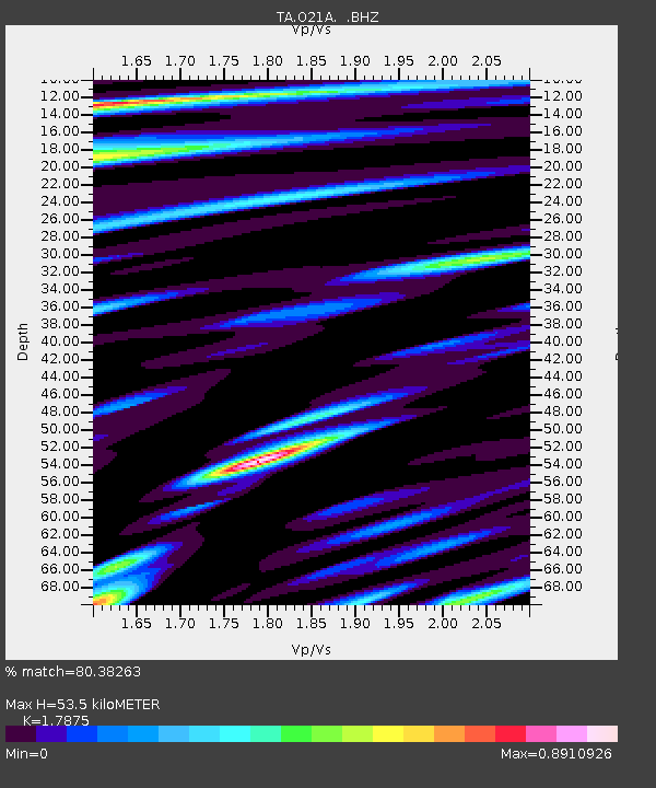
| Estimated Moho Depth: |
53.5 km |
| Estimated Crust Vp/Vs: |
1.79 |
| Assumed Crust Vp: |
6.159 km/s |
| Estimated Crust Vs: |
3.445 km/s |
| Estimated Crust Poisson's Ratio: |
0.27 |
|
| Radial Match: |
80.38263 % |
| Radial Bump: |
400 |
| Transverse Match: |
73.17827 % |
| Transverse Bump: |
400 |
| SOD ConfigId: |
2556 |
| Insert Time: |
2010-03-06 07:00:21.949 +0000 |
| GWidth: |
2.5 |
| Max Bumps: |
400 |
| Tol: |
0.001 |
|

Signal To Noise
| Channel | StoN | STA | LTA |
| TA:O21A: :BHZ:20081011T10:47:33.250002Z | 4.7402616 | 1.3856521E-6 | 2.9231555E-7 |
| TA:O21A: :BHN:20081011T10:47:33.250002Z | 2.775416 | 6.560114E-7 | 2.363651E-7 |
| TA:O21A: :BHE:20081011T10:47:33.250002Z | 2.9807093 | 6.397785E-7 | 2.1463967E-7 |
| Arrivals |
| Ps | 7.3 SECOND |
| PpPs | 23 SECOND |
| PsPs/PpSs | 30 SECOND |


