You are here: Home > Network List > TA - USArray Transportable Network (new EarthScope stations) Stations List
> Station O21A Pagoda, CO, USA > Earthquake Result Viewer
O21A Pagoda, CO, USA - Earthquake Result Viewer
| Earthquake location: |
Vanuatu Islands |
| Earthquake latitude/longitude: |
-14.8/168.0 |
| Earthquake time(UTC): |
2008/11/07 (312) 07:19:35 GMT |
| Earthquake Depth: |
13 km |
| Earthquake Magnitude: |
6.0 MB, 6.3 MS, 6.4 MW, 6.4 MW |
| Earthquake Catalog/Contributor: |
WHDF/NEIC |
|
| Network: |
TA USArray Transportable Network (new EarthScope stations) |
| Station: |
O21A Pagoda, CO, USA |
| Lat/Lon: |
40.21 N/107.47 W |
| Elevation: |
2343 m |
|
| Distance: |
95.3 deg |
| Az: |
49.953 deg |
| Baz: |
255.197 deg |
| Ray Param: |
0.040814426 |
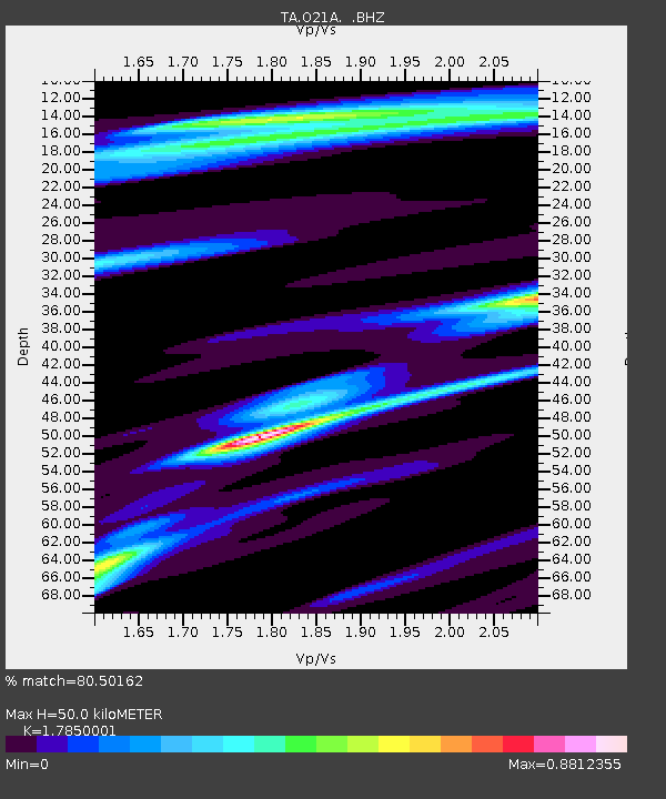
| Estimated Moho Depth: |
50.0 km |
| Estimated Crust Vp/Vs: |
1.79 |
| Assumed Crust Vp: |
6.159 km/s |
| Estimated Crust Vs: |
3.45 km/s |
| Estimated Crust Poisson's Ratio: |
0.27 |
|
| Radial Match: |
80.50162 % |
| Radial Bump: |
257 |
| Transverse Match: |
67.11691 % |
| Transverse Bump: |
337 |
| SOD ConfigId: |
2658 |
| Insert Time: |
2010-03-06 07:00:27.544 +0000 |
| GWidth: |
2.5 |
| Max Bumps: |
400 |
| Tol: |
0.001 |
|

Signal To Noise
| Channel | StoN | STA | LTA |
| TA:O21A: :BHZ:20081107T07:32:27.600015Z | 2.315555 | 3.6499725E-7 | 1.5762839E-7 |
| TA:O21A: :BHN:20081107T07:32:27.600015Z | 1.4682374 | 1.9763297E-7 | 1.3460559E-7 |
| TA:O21A: :BHE:20081107T07:32:27.600015Z | 1.1011004 | 1.4708074E-7 | 1.3357614E-7 |
| Arrivals |
| Ps | 6.5 SECOND |
| PpPs | 22 SECOND |
| PsPs/PpSs | 29 SECOND |


