You are here: Home > Network List > CN - Canadian National Seismograph Network Stations List
> Station INK INUVIK, NT > Earthquake Result Viewer
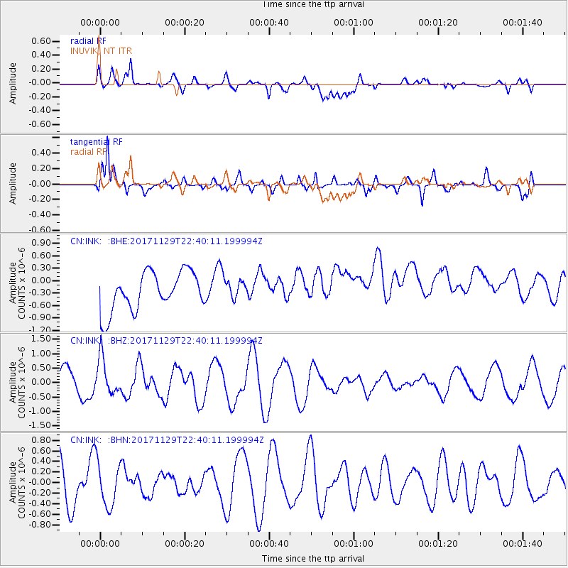
INK INUVIK, NT - Earthquake Result Viewer
*The percent match for this event was below the threshold and hence no stack was calculated.
| Earthquake location: |
Kuril Islands |
| Earthquake latitude/longitude: |
45.2/146.3 |
| Earthquake time(UTC): |
2017/11/29 (333) 22:32:23 GMT |
| Earthquake Depth: |
10 km |
| Earthquake Magnitude: |
5.4 Mww |
| Earthquake Catalog/Contributor: |
NEIC PDE/us |
|
| Network: |
CN Canadian National Seismograph Network |
| Station: |
INK INUVIK, NT |
| Lat/Lon: |
68.31 N/133.53 W |
| Elevation: |
44 m |
|
| Distance: |
45.5 deg |
| Az: |
30.919 deg |
| Baz: |
282.233 deg |
| Ray Param: |
$rayparam |
*The percent match for this event was below the threshold and hence was not used in the summary stack. |
|
| Radial Match: |
52.176666 % |
| Radial Bump: |
400 |
| Transverse Match: |
82.64355 % |
| Transverse Bump: |
400 |
| SOD ConfigId: |
13570011 |
| Insert Time: |
2019-04-29 08:09:22.281 +0000 |
| GWidth: |
2.5 |
| Max Bumps: |
400 |
| Tol: |
0.001 |
|
Signal To Noise
| Channel | StoN | STA | LTA |
| CN:INK: :BHZ:20171129T22:40:11.199994Z | 1.6027794 | 6.4887143E-7 | 4.048414E-7 |
| CN:INK: :BHN:20171129T22:40:11.199994Z | 1.065193 | 4.0132622E-7 | 3.767638E-7 |
| CN:INK: :BHE:20171129T22:40:11.199994Z | 0.4486588 | 2.0516521E-7 | 4.572856E-7 |
| Arrivals |
| Ps | |
| PpPs | |
| PsPs/PpSs | |


