You are here: Home > Network List > IU - Global Seismograph Network (GSN - IRIS/USGS) Stations List
> Station SFJD Sondre Stromfjord, Greenland > Earthquake Result Viewer
SFJD Sondre Stromfjord, Greenland - Earthquake Result Viewer
| Earthquake location: |
Afghanistan-Tajikistan Bord Reg. |
| Earthquake latitude/longitude: |
36.5/71.2 |
| Earthquake time(UTC): |
2016/04/10 (101) 10:28:58 GMT |
| Earthquake Depth: |
210 km |
| Earthquake Magnitude: |
6.6 MWB |
| Earthquake Catalog/Contributor: |
NEIC PDE/NEIC COMCAT |
|
| Network: |
IU Global Seismograph Network (GSN - IRIS/USGS) |
| Station: |
SFJD Sondre Stromfjord, Greenland |
| Lat/Lon: |
67.00 N/50.62 W |
| Elevation: |
330 m |
|
| Distance: |
67.8 deg |
| Az: |
338.848 deg |
| Baz: |
47.719 deg |
| Ray Param: |
0.056108315 |
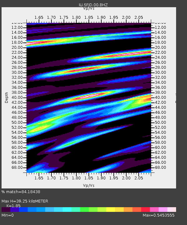
| Estimated Moho Depth: |
39.25 km |
| Estimated Crust Vp/Vs: |
1.85 |
| Assumed Crust Vp: |
6.459 km/s |
| Estimated Crust Vs: |
3.492 km/s |
| Estimated Crust Poisson's Ratio: |
0.29 |
|
| Radial Match: |
84.18438 % |
| Radial Bump: |
306 |
| Transverse Match: |
67.17767 % |
| Transverse Bump: |
376 |
| SOD ConfigId: |
1475611 |
| Insert Time: |
2016-04-24 10:38:19.704 +0000 |
| GWidth: |
2.5 |
| Max Bumps: |
400 |
| Tol: |
0.001 |
|

Signal To Noise
| Channel | StoN | STA | LTA |
| IU:SFJD:00:BHZ:20160410T10:39:02.768992Z | 9.598262 | 7.680843E-6 | 8.002326E-7 |
| IU:SFJD:00:BH1:20160410T10:39:02.768992Z | 4.151749 | 1.8758548E-6 | 4.5182276E-7 |
| IU:SFJD:00:BH2:20160410T10:39:02.768992Z | 7.07632 | 2.754568E-6 | 3.892656E-7 |
| Arrivals |
| Ps | 5.4 SECOND |
| PpPs | 17 SECOND |
| PsPs/PpSs | 22 SECOND |


