You are here: Home > Network List > NE - New England Seismic Network Stations List
> Station EMMW Machias, ME, USA > Earthquake Result Viewer
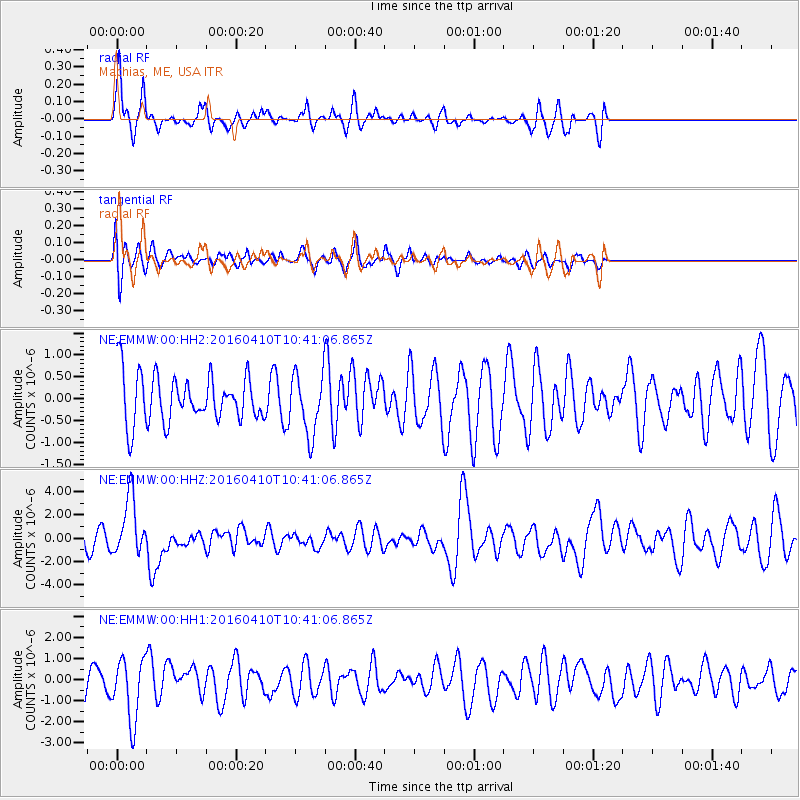
EMMW Machias, ME, USA - Earthquake Result Viewer
*The percent match for this event was below the threshold and hence no stack was calculated.
| Earthquake location: |
Afghanistan-Tajikistan Bord Reg. |
| Earthquake latitude/longitude: |
36.5/71.2 |
| Earthquake time(UTC): |
2016/04/10 (101) 10:28:58 GMT |
| Earthquake Depth: |
210 km |
| Earthquake Magnitude: |
6.6 MWB |
| Earthquake Catalog/Contributor: |
NEIC PDE/NEIC COMCAT |
|
| Network: |
NE New England Seismic Network |
| Station: |
EMMW Machias, ME, USA |
| Lat/Lon: |
44.71 N/67.46 W |
| Elevation: |
35 m |
|
| Distance: |
90.9 deg |
| Az: |
331.869 deg |
| Baz: |
32.197 deg |
| Ray Param: |
$rayparam |
*The percent match for this event was below the threshold and hence was not used in the summary stack. |
|
| Radial Match: |
75.84798 % |
| Radial Bump: |
380 |
| Transverse Match: |
61.962624 % |
| Transverse Bump: |
400 |
| SOD ConfigId: |
1475611 |
| Insert Time: |
2016-04-24 10:39:07.554 +0000 |
| GWidth: |
2.5 |
| Max Bumps: |
400 |
| Tol: |
0.001 |
|
Signal To Noise
| Channel | StoN | STA | LTA |
| NE:EMMW:00:HHZ:20160410T10:41:06.865Z | 3.1706314 | 2.4556336E-6 | 7.7449357E-7 |
| NE:EMMW:00:HH1:20160410T10:41:06.865Z | 2.408294 | 1.4677017E-6 | 6.0943626E-7 |
| NE:EMMW:00:HH2:20160410T10:41:06.865Z | 1.2514349 | 6.777222E-7 | 5.4155606E-7 |
| Arrivals |
| Ps | |
| PpPs | |
| PsPs/PpSs | |


