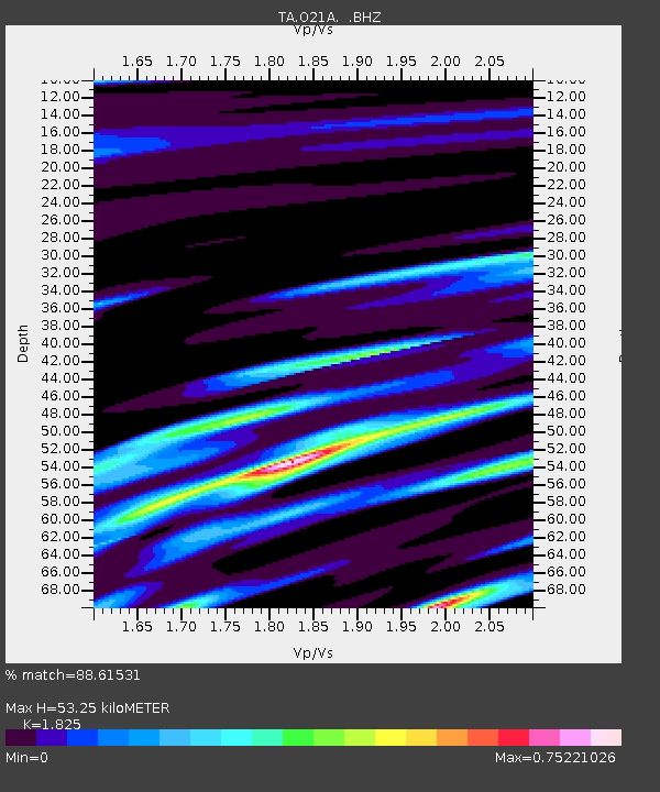
O21A Pagoda, CO, USA - Earthquake Result Viewer
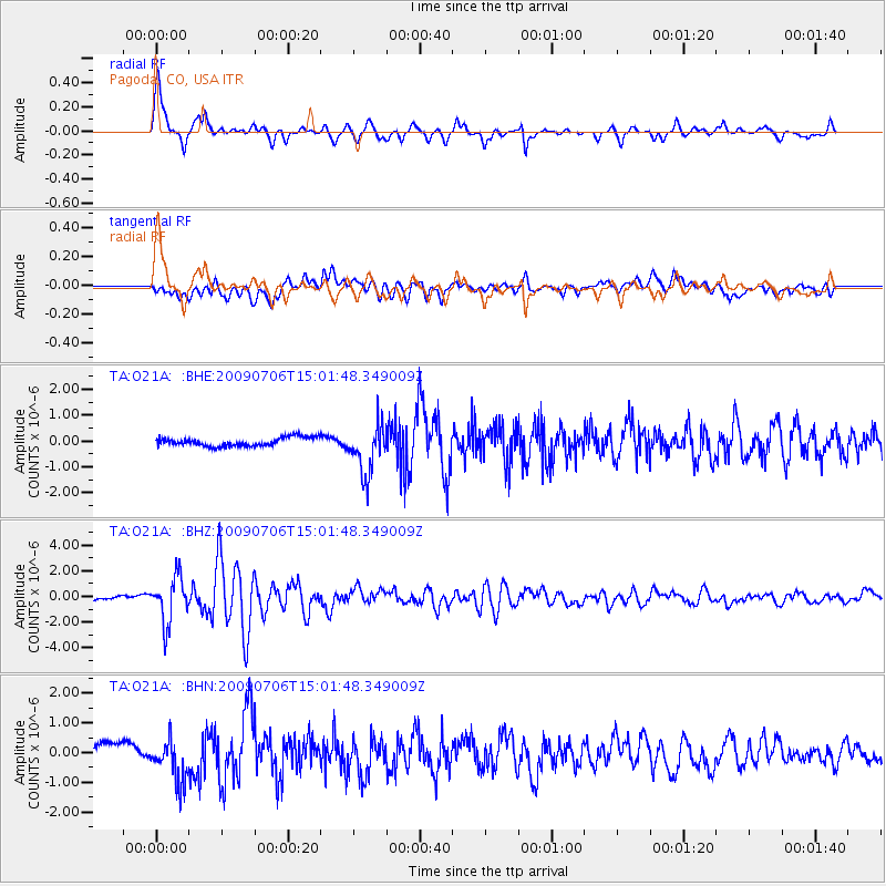
Earthquake location: Rat Islands, Aleutian Islands
Earthquake latitude/longitude: 50.4/177.0
Earthquake time(UTC): 2009/07/06 (187) 14:53:12 GMT
Earthquake Depth: 22 km
Earthquake Magnitude: 6.0 MB, 5.8 MS, 6.1 MW, 6.0 MW
Earthquake Catalog/Contributor: WHDF/NEIC
Network: TA USArray Transportable Network (new EarthScope stations)
Station: O21A Pagoda, CO, USA
Lat/Lon: 40.21 N/107.47 W
Elevation: 2343 m
Distance: 51.9 deg
Az: 70.386 deg
Baz: 308.126 deg
Ray Param: 0.06706352
Estimated Moho Depth: 53.25 km
Estimated Crust Vp/Vs: 1.83
Assumed Crust Vp: 6.159 km/s
Estimated Crust Vs: 3.375 km/s
Estimated Crust Poisson's Ratio: 0.29
Radial Match: 88.61531 %
Radial Bump: 346
Transverse Match: 64.50644 %
Transverse Bump: 400
SOD ConfigId: 2648
Insert Time: 2010-03-06 07:01:16.927 +0000
GWidth: 2.5
Max Bumps: 400
Tol: 0.001

Signal To Noise

ChannelStoNSTALTA
TA:O21A: :BHZ:20090706T15:01:48.349009Z11.751041.7720389E-61.5079846E-7
TA:O21A: :BHN:20090706T15:01:48.349009Z3.12810877.159147E-72.2886503E-7
TA:O21A: :BHE:20090706T15:01:48.349009Z5.76479249.476958E-71.6439375E-7
Arrivals
Ps7.5 SECOND
PpPs23 SECOND
PsPs/PpSs31 SECOND