You are here: Home > Network List > TA - USArray Transportable Network (new EarthScope stations) Stations List
> Station I23K Minto, Yukon-Koyukuk, AK, USA > Earthquake Result Viewer
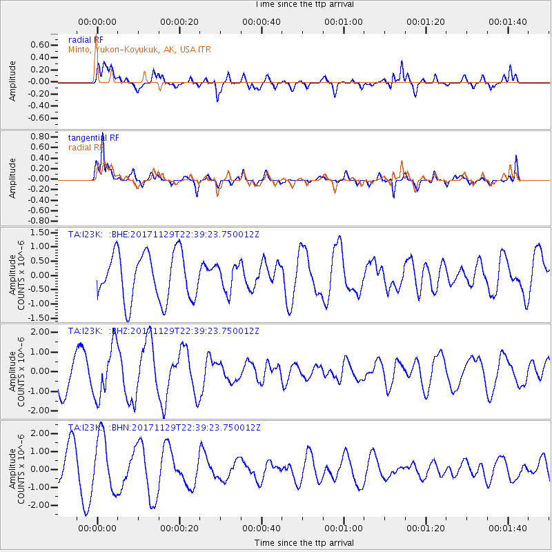
I23K Minto, Yukon-Koyukuk, AK, USA - Earthquake Result Viewer
*The percent match for this event was below the threshold and hence no stack was calculated.
| Earthquake location: |
Kuril Islands |
| Earthquake latitude/longitude: |
45.2/146.3 |
| Earthquake time(UTC): |
2017/11/29 (333) 22:32:23 GMT |
| Earthquake Depth: |
10 km |
| Earthquake Magnitude: |
5.4 Mww |
| Earthquake Catalog/Contributor: |
NEIC PDE/us |
|
| Network: |
TA USArray Transportable Network (new EarthScope stations) |
| Station: |
I23K Minto, Yukon-Koyukuk, AK, USA |
| Lat/Lon: |
65.15 N/149.36 W |
| Elevation: |
149 m |
|
| Distance: |
39.6 deg |
| Az: |
36.675 deg |
| Baz: |
271.93 deg |
| Ray Param: |
$rayparam |
*The percent match for this event was below the threshold and hence was not used in the summary stack. |
|
| Radial Match: |
54.690674 % |
| Radial Bump: |
400 |
| Transverse Match: |
77.15432 % |
| Transverse Bump: |
361 |
| SOD ConfigId: |
13570011 |
| Insert Time: |
2019-04-29 08:13:56.372 +0000 |
| GWidth: |
2.5 |
| Max Bumps: |
400 |
| Tol: |
0.001 |
|
Signal To Noise
| Channel | StoN | STA | LTA |
| TA:I23K: :BHZ:20171129T22:39:23.750012Z | 1.8200665 | 1.3369806E-6 | 7.3457795E-7 |
| TA:I23K: :BHN:20171129T22:39:23.750012Z | 1.6121037 | 1.5562724E-6 | 9.653675E-7 |
| TA:I23K: :BHE:20171129T22:39:23.750012Z | 0.59156424 | 4.8274956E-7 | 8.16056E-7 |
| Arrivals |
| Ps | |
| PpPs | |
| PsPs/PpSs | |


