You are here: Home > Network List > UW - Pacific Northwest Regional Seismic Network Stations List
> Station LTY Liberty (broad-band) > Earthquake Result Viewer
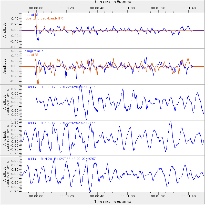
LTY Liberty (broad-band) - Earthquake Result Viewer
*The percent match for this event was below the threshold and hence no stack was calculated.
| Earthquake location: |
Kuril Islands |
| Earthquake latitude/longitude: |
45.2/146.3 |
| Earthquake time(UTC): |
2017/11/29 (333) 22:32:23 GMT |
| Earthquake Depth: |
10 km |
| Earthquake Magnitude: |
5.4 Mww |
| Earthquake Catalog/Contributor: |
NEIC PDE/us |
|
| Network: |
UW Pacific Northwest Regional Seismic Network |
| Station: |
LTY Liberty (broad-band) |
| Lat/Lon: |
47.26 N/120.66 W |
| Elevation: |
970 m |
|
| Distance: |
60.5 deg |
| Az: |
51.381 deg |
| Baz: |
305.797 deg |
| Ray Param: |
$rayparam |
*The percent match for this event was below the threshold and hence was not used in the summary stack. |
|
| Radial Match: |
63.88215 % |
| Radial Bump: |
400 |
| Transverse Match: |
62.88893 % |
| Transverse Bump: |
400 |
| SOD ConfigId: |
13570011 |
| Insert Time: |
2019-04-29 08:15:04.925 +0000 |
| GWidth: |
2.5 |
| Max Bumps: |
400 |
| Tol: |
0.001 |
|
Signal To Noise
| Channel | StoN | STA | LTA |
| UW:LTY: :BHZ:20171129T22:42:02.024976Z | 2.0024328 | 5.63126E-7 | 2.812209E-7 |
| UW:LTY: :BHN:20171129T22:42:02.024976Z | 1.0826643 | 3.307442E-7 | 3.05491E-7 |
| UW:LTY: :BHE:20171129T22:42:02.024976Z | 3.3305516 | 7.2435455E-7 | 2.1748785E-7 |
| Arrivals |
| Ps | |
| PpPs | |
| PsPs/PpSs | |


