You are here: Home > Network List > TA - USArray Transportable Network (new EarthScope stations) Stations List
> Station D23K Nanushuk River, AK USA > Earthquake Result Viewer
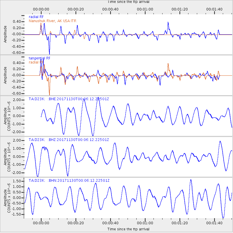
D23K Nanushuk River, AK USA - Earthquake Result Viewer
*The percent match for this event was below the threshold and hence no stack was calculated.
| Earthquake location: |
Banda Sea |
| Earthquake latitude/longitude: |
-6.8/129.8 |
| Earthquake time(UTC): |
2017/11/29 (333) 23:53:50 GMT |
| Earthquake Depth: |
160 km |
| Earthquake Magnitude: |
5.5 Mww |
| Earthquake Catalog/Contributor: |
NEIC PDE/us |
|
| Network: |
TA USArray Transportable Network (new EarthScope stations) |
| Station: |
D23K Nanushuk River, AK USA |
| Lat/Lon: |
68.97 N/150.68 W |
| Elevation: |
406 m |
|
| Distance: |
92.5 deg |
| Az: |
20.817 deg |
| Baz: |
257.847 deg |
| Ray Param: |
$rayparam |
*The percent match for this event was below the threshold and hence was not used in the summary stack. |
|
| Radial Match: |
67.5308 % |
| Radial Bump: |
400 |
| Transverse Match: |
77.0633 % |
| Transverse Bump: |
355 |
| SOD ConfigId: |
13570011 |
| Insert Time: |
2019-04-29 08:17:50.411 +0000 |
| GWidth: |
2.5 |
| Max Bumps: |
400 |
| Tol: |
0.001 |
|
Signal To Noise
| Channel | StoN | STA | LTA |
| TA:D23K: :BHZ:20171130T00:06:12.22501Z | 1.0944663 | 9.3130836E-7 | 8.5092466E-7 |
| TA:D23K: :BHN:20171130T00:06:12.22501Z | 0.3122655 | 1.6603924E-7 | 5.317246E-7 |
| TA:D23K: :BHE:20171130T00:06:12.22501Z | 1.5453928 | 1.7441529E-6 | 1.1286147E-6 |
| Arrivals |
| Ps | |
| PpPs | |
| PsPs/PpSs | |


