You are here: Home > Network List > US - United States National Seismic Network Stations List
> Station DGMT Dagmar, Montana, USA > Earthquake Result Viewer
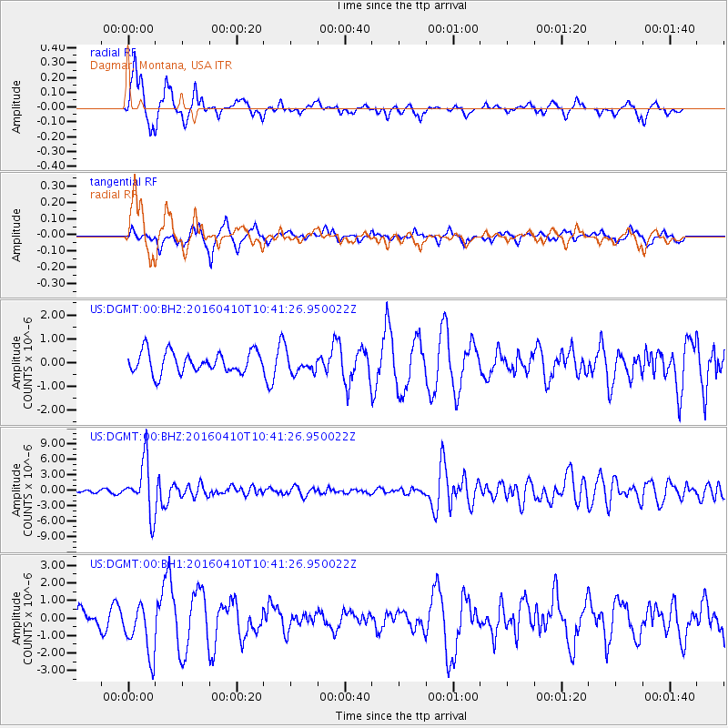
DGMT Dagmar, Montana, USA - Earthquake Result Viewer
*The percent match for this event was below the threshold and hence no stack was calculated.
| Earthquake location: |
Afghanistan-Tajikistan Bord Reg. |
| Earthquake latitude/longitude: |
36.5/71.2 |
| Earthquake time(UTC): |
2016/04/10 (101) 10:28:58 GMT |
| Earthquake Depth: |
210 km |
| Earthquake Magnitude: |
6.6 MWB |
| Earthquake Catalog/Contributor: |
NEIC PDE/NEIC COMCAT |
|
| Network: |
US United States National Seismic Network |
| Station: |
DGMT Dagmar, Montana, USA |
| Lat/Lon: |
48.47 N/104.20 W |
| Elevation: |
0.0 m |
|
| Distance: |
95.3 deg |
| Az: |
356.895 deg |
| Baz: |
3.761 deg |
| Ray Param: |
$rayparam |
*The percent match for this event was below the threshold and hence was not used in the summary stack. |
|
| Radial Match: |
77.67438 % |
| Radial Bump: |
351 |
| Transverse Match: |
55.044575 % |
| Transverse Bump: |
370 |
| SOD ConfigId: |
1475611 |
| Insert Time: |
2016-04-24 10:41:16.767 +0000 |
| GWidth: |
2.5 |
| Max Bumps: |
400 |
| Tol: |
0.001 |
|
Signal To Noise
| Channel | StoN | STA | LTA |
| US:DGMT:00:BHZ:20160410T10:41:26.950022Z | 23.953243 | 5.0927297E-6 | 2.1261127E-7 |
| US:DGMT:00:BH1:20160410T10:41:26.950022Z | 2.6202803 | 1.5246464E-6 | 5.818639E-7 |
| US:DGMT:00:BH2:20160410T10:41:26.950022Z | 0.84962535 | 3.7647686E-7 | 4.4310926E-7 |
| Arrivals |
| Ps | |
| PpPs | |
| PsPs/PpSs | |


