You are here: Home > Network List > US - United States National Seismic Network Stations List
> Station WRAK Wrangell Island, Southeastern Alaska, Alaska, USA > Earthquake Result Viewer
WRAK Wrangell Island, Southeastern Alaska, Alaska, USA - Earthquake Result Viewer
| Earthquake location: |
Afghanistan-Tajikistan Bord Reg. |
| Earthquake latitude/longitude: |
36.5/71.2 |
| Earthquake time(UTC): |
2016/04/10 (101) 10:28:58 GMT |
| Earthquake Depth: |
210 km |
| Earthquake Magnitude: |
6.6 MWB |
| Earthquake Catalog/Contributor: |
NEIC PDE/NEIC COMCAT |
|
| Network: |
US United States National Seismic Network |
| Station: |
WRAK Wrangell Island, Southeastern Alaska, Alaska, USA |
| Lat/Lon: |
56.42 N/132.35 W |
| Elevation: |
81 m |
|
| Distance: |
85.3 deg |
| Az: |
12.847 deg |
| Baz: |
341.189 deg |
| Ray Param: |
0.044350706 |
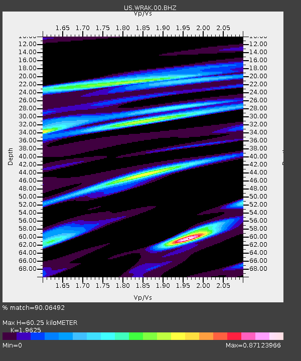
| Estimated Moho Depth: |
60.25 km |
| Estimated Crust Vp/Vs: |
1.96 |
| Assumed Crust Vp: |
6.597 km/s |
| Estimated Crust Vs: |
3.362 km/s |
| Estimated Crust Poisson's Ratio: |
0.32 |
|
| Radial Match: |
90.06492 % |
| Radial Bump: |
400 |
| Transverse Match: |
83.08422 % |
| Transverse Bump: |
400 |
| SOD ConfigId: |
1475611 |
| Insert Time: |
2016-04-24 10:42:58.316 +0000 |
| GWidth: |
2.5 |
| Max Bumps: |
400 |
| Tol: |
0.001 |
|
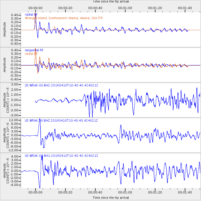
Signal To Noise
| Channel | StoN | STA | LTA |
| US:WRAK:00:BHZ:20160410T10:40:40.424021Z | 30.135944 | 5.6905897E-6 | 1.8883064E-7 |
| US:WRAK:00:BH1:20160410T10:40:40.424021Z | 15.233273 | 2.4759424E-6 | 1.6253516E-7 |
| US:WRAK:00:BH2:20160410T10:40:40.424021Z | 2.8226948 | 5.631657E-7 | 1.995135E-7 |
| Arrivals |
| Ps | 9.0 SECOND |
| PpPs | 26 SECOND |
| PsPs/PpSs | 35 SECOND |


