You are here: Home > Network List > GS - US Geological Survey Networks Stations List
> Station DEC07 Decatur Surface Seismic Site, Decatur, IL, USA > Earthquake Result Viewer
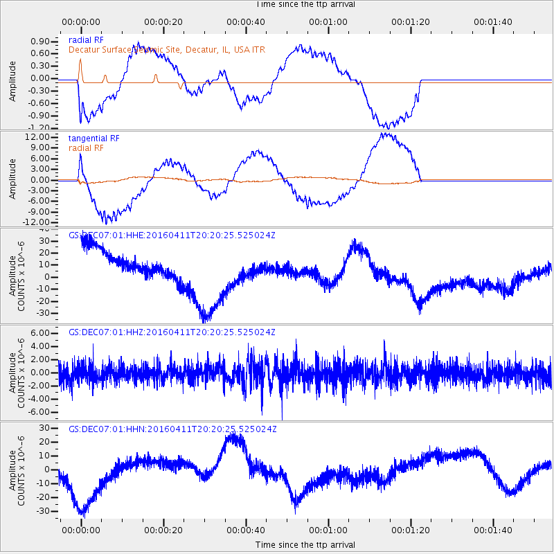
DEC07 Decatur Surface Seismic Site, Decatur, IL, USA - Earthquake Result Viewer
*The percent match for this event was below the threshold and hence no stack was calculated.
| Earthquake location: |
Rat Islands, Aleutian Islands |
| Earthquake latitude/longitude: |
51.8/176.6 |
| Earthquake time(UTC): |
2016/04/11 (102) 20:10:35 GMT |
| Earthquake Depth: |
22 km |
| Earthquake Magnitude: |
5.6 MB, 5.5 MB, 5.6 MI |
| Earthquake Catalog/Contributor: |
NEIC PDE/NEIC COMCAT |
|
| Network: |
GS US Geological Survey Networks |
| Station: |
DEC07 Decatur Surface Seismic Site, Decatur, IL, USA |
| Lat/Lon: |
39.86 N/88.90 W |
| Elevation: |
212 m |
|
| Distance: |
62.4 deg |
| Az: |
59.989 deg |
| Baz: |
315.735 deg |
| Ray Param: |
$rayparam |
*The percent match for this event was below the threshold and hence was not used in the summary stack. |
|
| Radial Match: |
44.266293 % |
| Radial Bump: |
400 |
| Transverse Match: |
69.45568 % |
| Transverse Bump: |
400 |
| SOD ConfigId: |
1475611 |
| Insert Time: |
2016-04-25 20:16:37.242 +0000 |
| GWidth: |
2.5 |
| Max Bumps: |
400 |
| Tol: |
0.001 |
|
Signal To Noise
| Channel | StoN | STA | LTA |
| GS:DEC07:01:HHZ:20160411T20:20:25.525024Z | 1.0850551 | 1.3055111E-6 | 1.203175E-6 |
| GS:DEC07:01:HHN:20160411T20:20:25.525024Z | 4.6564507 | 3.320378E-5 | 7.130706E-6 |
| GS:DEC07:01:HHE:20160411T20:20:25.525024Z | 3.5327656 | 3.866477E-5 | 1.0944618E-5 |
| Arrivals |
| Ps | |
| PpPs | |
| PsPs/PpSs | |


