You are here: Home > Network List > TA - USArray Transportable Network (new EarthScope stations) Stations List
> Station M22A Cedar Creek Ranch, Saratoga, WY, USA > Earthquake Result Viewer
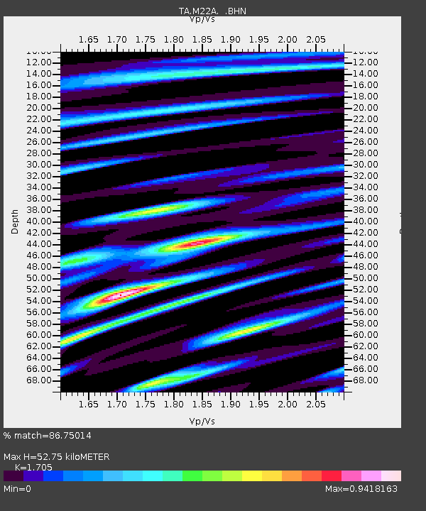
M22A Cedar Creek Ranch, Saratoga, WY, USA - Earthquake Result Viewer
| Earthquake location: |
South Of Fiji Islands |
| Earthquake latitude/longitude: |
-26.0/-177.5 |
| Earthquake time(UTC): |
2007/12/09 (343) 07:28:20 GMT |
| Earthquake Depth: |
152 km |
| Earthquake Magnitude: |
7.0 MB, 7.8 MW, 7.7 MW |
| Earthquake Catalog/Contributor: |
WHDF/NEIC |
|
| Network: |
TA USArray Transportable Network (new EarthScope stations) |
| Station: |
M22A Cedar Creek Ranch, Saratoga, WY, USA |
| Lat/Lon: |
41.40 N/106.60 W |
| Elevation: |
2334 m |
|
| Distance: |
93.8 deg |
| Az: |
45.437 deg |
| Baz: |
238.471 deg |
| Ray Param: |
0.041094467 |
| Estimated Moho Depth: |
52.75 km |
| Estimated Crust Vp/Vs: |
1.71 |
| Assumed Crust Vp: |
6.159 km/s |
| Estimated Crust Vs: |
3.612 km/s |
| Estimated Crust Poisson's Ratio: |
0.24 |
|
| Radial Match: |
86.75014 % |
| Radial Bump: |
400 |
| Transverse Match: |
66.43395 % |
| Transverse Bump: |
400 |
| SOD ConfigId: |
2564 |
| Insert Time: |
2010-03-06 07:03:56.451 +0000 |
| GWidth: |
2.5 |
| Max Bumps: |
400 |
| Tol: |
0.001 |
|

Signal To Noise
| Channel | StoN | STA | LTA |
| TA:M22A: :BHN:20071209T07:40:49.150017Z | 1.018057 | 1.6499801E-7 | 1.6207147E-7 |
| TA:M22A: :BHE:20071209T07:40:49.150017Z | 1.6901927 | 2.4665138E-7 | 1.4593093E-7 |
| TA:M22A: :BHZ:20071209T07:40:49.150017Z | 4.1055965 | 5.7849655E-7 | 1.4090439E-7 |
| Arrivals |
| Ps | 6.2 SECOND |
| PpPs | 23 SECOND |
| PsPs/PpSs | 29 SECOND |


