You are here: Home > Network List > TA - USArray Transportable Network (new EarthScope stations) Stations List
> Station M22A Cedar Creek Ranch, Saratoga, WY, USA > Earthquake Result Viewer
M22A Cedar Creek Ranch, Saratoga, WY, USA - Earthquake Result Viewer
| Earthquake location: |
Central Mid-Atlantic Ridge |
| Earthquake latitude/longitude: |
-1.2/-23.5 |
| Earthquake time(UTC): |
2008/04/24 (115) 12:14:49 GMT |
| Earthquake Depth: |
10 km |
| Earthquake Magnitude: |
6.0 MS, 5.4 MB, 6.5 MW, 6.4 MW |
| Earthquake Catalog/Contributor: |
WHDF/NEIC |
|
| Network: |
TA USArray Transportable Network (new EarthScope stations) |
| Station: |
M22A Cedar Creek Ranch, Saratoga, WY, USA |
| Lat/Lon: |
41.40 N/106.60 W |
| Elevation: |
2334 m |
|
| Distance: |
85.6 deg |
| Az: |
311.491 deg |
| Baz: |
95.425 deg |
| Ray Param: |
0.044640478 |
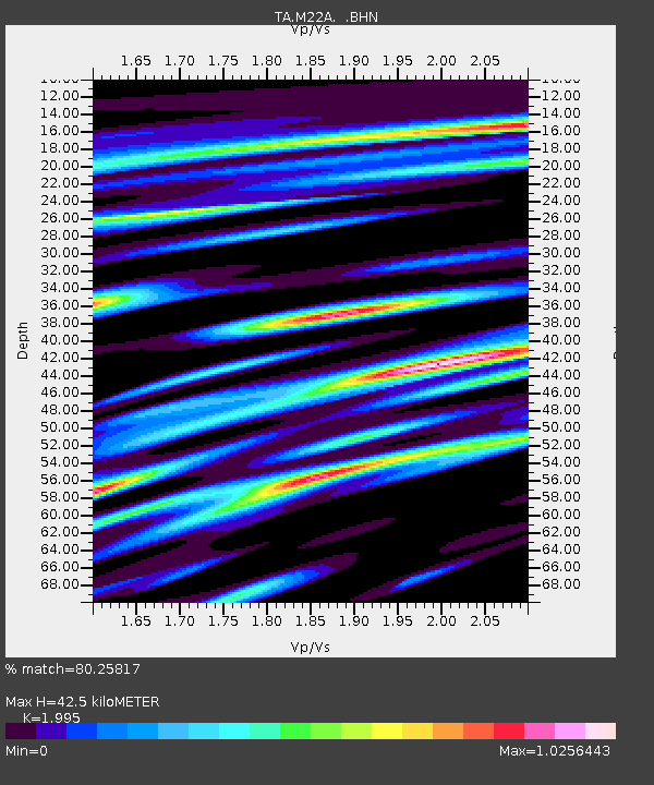
| Estimated Moho Depth: |
42.5 km |
| Estimated Crust Vp/Vs: |
2.00 |
| Assumed Crust Vp: |
6.159 km/s |
| Estimated Crust Vs: |
3.087 km/s |
| Estimated Crust Poisson's Ratio: |
0.33 |
|
| Radial Match: |
80.25817 % |
| Radial Bump: |
400 |
| Transverse Match: |
57.865246 % |
| Transverse Bump: |
400 |
| SOD ConfigId: |
2504 |
| Insert Time: |
2010-03-06 07:04:02.117 +0000 |
| GWidth: |
2.5 |
| Max Bumps: |
400 |
| Tol: |
0.001 |
|

Signal To Noise
| Channel | StoN | STA | LTA |
| TA:M22A: :BHN:20080424T12:26:56.950029Z | 2.0422401 | 1.5984442E-7 | 7.826915E-8 |
| TA:M22A: :BHE:20080424T12:26:56.950029Z | 1.2979765 | 1.3588206E-7 | 1.0468761E-7 |
| TA:M22A: :BHZ:20080424T12:26:56.950029Z | 0.8012123 | 8.08763E-8 | 1.0094241E-7 |
| Arrivals |
| Ps | 7.0 SECOND |
| PpPs | 20 SECOND |
| PsPs/PpSs | 27 SECOND |


