You are here: Home > Network List > IU - Global Seismograph Network (GSN - IRIS/USGS) Stations List
> Station PMG Port Moresby, New Guinea > Earthquake Result Viewer
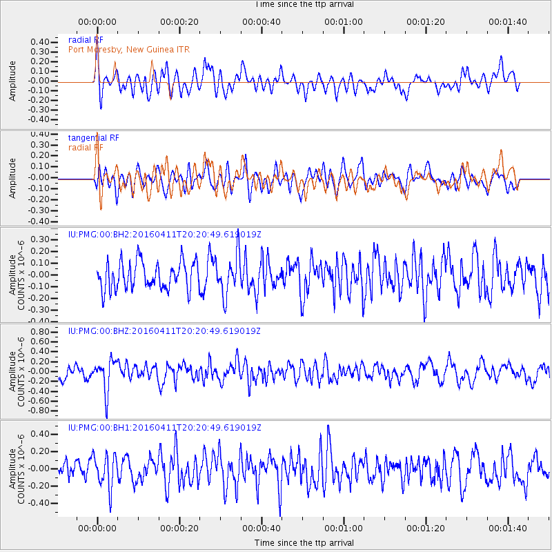
PMG Port Moresby, New Guinea - Earthquake Result Viewer
*The percent match for this event was below the threshold and hence no stack was calculated.
| Earthquake location: |
Rat Islands, Aleutian Islands |
| Earthquake latitude/longitude: |
51.8/176.6 |
| Earthquake time(UTC): |
2016/04/11 (102) 20:10:35 GMT |
| Earthquake Depth: |
22 km |
| Earthquake Magnitude: |
5.6 MB, 5.5 MB, 5.6 MI |
| Earthquake Catalog/Contributor: |
NEIC PDE/NEIC COMCAT |
|
| Network: |
IU Global Seismograph Network (GSN - IRIS/USGS) |
| Station: |
PMG Port Moresby, New Guinea |
| Lat/Lon: |
9.40 S/147.16 E |
| Elevation: |
90 m |
|
| Distance: |
66.1 deg |
| Az: |
212.072 deg |
| Baz: |
19.503 deg |
| Ray Param: |
$rayparam |
*The percent match for this event was below the threshold and hence was not used in the summary stack. |
|
| Radial Match: |
60.13378 % |
| Radial Bump: |
400 |
| Transverse Match: |
43.236748 % |
| Transverse Bump: |
400 |
| SOD ConfigId: |
1475611 |
| Insert Time: |
2016-04-25 20:21:17.586 +0000 |
| GWidth: |
2.5 |
| Max Bumps: |
400 |
| Tol: |
0.001 |
|
Signal To Noise
| Channel | StoN | STA | LTA |
| IU:PMG:00:BHZ:20160411T20:20:49.619019Z | 2.1837568 | 3.3093954E-7 | 1.5154596E-7 |
| IU:PMG:00:BH1:20160411T20:20:49.619019Z | 1.5013452 | 1.8885105E-7 | 1.2578789E-7 |
| IU:PMG:00:BH2:20160411T20:20:49.619019Z | 1.4572688 | 1.715477E-7 | 1.1771863E-7 |
| Arrivals |
| Ps | |
| PpPs | |
| PsPs/PpSs | |


