You are here: Home > Network List > TA - USArray Transportable Network (new EarthScope stations) Stations List
> Station M22A Cedar Creek Ranch, Saratoga, WY, USA > Earthquake Result Viewer
M22A Cedar Creek Ranch, Saratoga, WY, USA - Earthquake Result Viewer

| Earthquake location: |
Iceland |
| Earthquake latitude/longitude: |
64.0/-21.0 |
| Earthquake time(UTC): |
2008/05/29 (150) 15:46:00 GMT |
| Earthquake Depth: |
10 km |
| Earthquake Magnitude: |
6.0 MB, 6.2 MS, 6.3 MW, 6.2 MW |
| Earthquake Catalog/Contributor: |
WHDF/NEIC |
|
| Network: |
TA USArray Transportable Network (new EarthScope stations) |
| Station: |
M22A Cedar Creek Ranch, Saratoga, WY, USA |
| Lat/Lon: |
41.40 N/106.60 W |
| Elevation: |
2334 m |
|
| Distance: |
51.9 deg |
| Az: |
287.63 deg |
| Baz: |
33.938 deg |
| Ray Param: |
0.06710538 |
| Estimated Moho Depth: |
66.0 km |
| Estimated Crust Vp/Vs: |
1.63 |
| Assumed Crust Vp: |
6.159 km/s |
| Estimated Crust Vs: |
3.778 km/s |
| Estimated Crust Poisson's Ratio: |
0.20 |
|
| Radial Match: |
82.30388 % |
| Radial Bump: |
400 |
| Transverse Match: |
77.18846 % |
| Transverse Bump: |
400 |
| SOD ConfigId: |
2504 |
| Insert Time: |
2010-03-06 07:04:12.386 +0000 |
| GWidth: |
2.5 |
| Max Bumps: |
400 |
| Tol: |
0.001 |
|
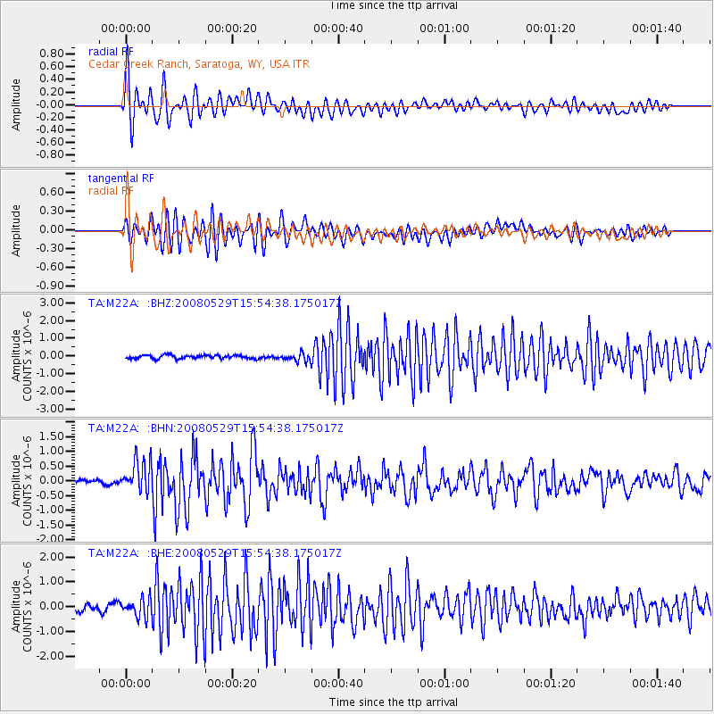
Signal To Noise
| Channel | StoN | STA | LTA |
| TA:M22A: :BHN:20080529T15:54:38.175017Z | 6.0710487 | 5.3947326E-7 | 8.8859984E-8 |
| TA:M22A: :BHE:20080529T15:54:38.175017Z | 3.3177269 | 3.6616524E-7 | 1.103663E-7 |
| TA:M22A: :BHZ:20080529T15:54:38.175017Z | 2.3261144 | 2.2702206E-7 | 9.7597116E-8 |
| Arrivals |
| Ps | 7.1 SECOND |
| PpPs | 27 SECOND |
| PsPs/PpSs | 34 SECOND |


